Chicago and Illinois leaders recently came together to celebrate breaking ground on the long awaited CTA L extension into the Far South Side. The almost $6 billion Red Line Extension will add 4 new stations and 5.5 miles of track, as well as a substantial new train yard to store the new trains needed to serve the extension.
This project has been planned from the beginning as part of the South Side Rapid Transit line which dates back to a 1958 CTA Transportation plan New Horizons for Chicago’s Metropolitan Area. It was initially conceived as a rapid transit line down the South Expressway with a ultimate terminal at 103rd and Doty Avenue and a separate Blue Island branch to 119th near the city limits. The first phase to 95th was completed in 1969 as the Dan Ryan branch and was the first substantial new rapid transit line in Chicago after WW2. It followed the freeway rapid transit model established with the Forest Park branch of the current Blue Line in the Eisenhower Expressway, completed in 1958, which replaced the existing Garfield park branch.
This method of bundling rapid transit and grade separated highways was an innovative model that has been influential not only in Chicago but across the USA with numerous other national rail transit lines adopting this alignment choice. Freeway rapid transit provides major cost savings over traditional elevated or tunneled rail lines at the expense of rider comfort and transit supportive land use. Waiting in the middle of a noisy and polluted freeway is extremely unpleasant, especially without any noise barriers, and the prevention of nearby housing in walking distance means riders will have to transfer from buses or take a dangerous and uncomfortable walk and bike ride to access stations. While freeway rapid transit is certainly preferred over the alternative of no rapid transit, this model is ultimately not very conducive for generating transit ridership or compelling mode shift from driving.
The subsequent branches of the Dan Ryan branch were never built due to various fiscal crises with the city and CTA and the Southwest Rapid Transit project, the Orange Line which opened in 1993, was deemed a greater priority. Planning for the Red Line Extension continued however to due to historical commitments and organizational inertia and the decades planning process culminated with the start of constructional on April 24th.
“Today’s groundbreaking demonstrates our shared commitment to transit equity and opportunity for every Chicagoan,” said Chicago Mayor Brandon Johnson. “Far South Side residents have waited decades for this vital rail service to come to life. Our administration never wavered in our determination to finally secure this project and will continue to direct investments in housing and neighborhood development to support the transit-oriented revitalization of the surrounding communities.”
Commitment to equity is a noble goal, but should not be the sole criteria used when making billion dollar decisions about where to build new rail. The extremely long planning process, paucity of federal funding, and ever escalating transit construction costs means this will likely be the only rapid transit line Chicago sees for decades. The Trump administration tried to deny CTA federal funds promised during the Biden administration, although eventually the funds were released by order of a Judge following a successful lawsuit. However this demonstrates the hostility towards cities and transit by the current White House and future Republican presidents. Feckless Democrats more concerned with passing gas tax cuts are also unlikely to be champions for transit in the future either, with substantial service cuts occurring in strong Democratic states like Oregon refusing to properly fund transit in Portland.
The post pandemic environment for transit is dire outside of a few select cities like NYC. which is flush in cash from congestion pricing and has strong state support. Chicago and Illinois are luckily that state leaders valued transit enough to pass significant funding with the NITA Act, which recently went into effect on June 1st and provides $1.5 billion in annual fundings for transit, as well as implementing a slew of organizational restructurings and other transit support policies like removing parking minimums near frequent transit.
However, expensive, low ridership rail projects like the Red Line Extension stand to make the public distrusting of CTA as responsible fiduciaries of taxpayer money, as well as accentuate the Republican stance of transit as wasteful government spending. The South Side has lost a tremendous amount of people since the the project was first proposed in the 1950s. While revitalization of the area with new transit service is an admirable goal, it seems implausible that a new L line so far from the Loop will generate substantial new investment in the area when existing underperforming L lines much closer to the economic center of the Chicago have failed to generate much new investment recently.
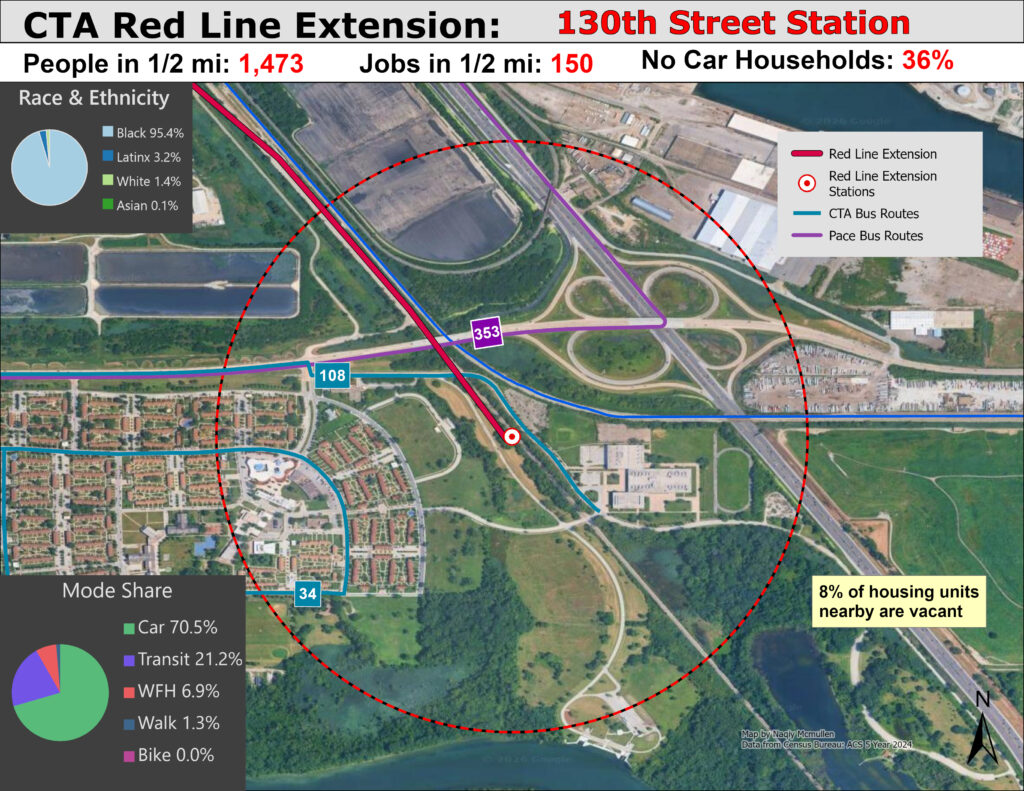
Following the recent ground breaking of the RLE, I took a trip to survey the new station locations and was dismayed at what I saw. I knew the South Side suffered from population loss and disinvestment, but was still surprised to see the extent of abandoned houses and any lack of urban vitality near future Red Line stations. To quantify the dismal land use I mapped the future stations, using geospatial analysis with 1/2 mile radiuses, the traditional transit catchment area, with the overall future line shown below. While it is too late to stop the line from being built, empirically examining the reasons why this project is flawed is helpful to avoid future mistakes and act as a case study.
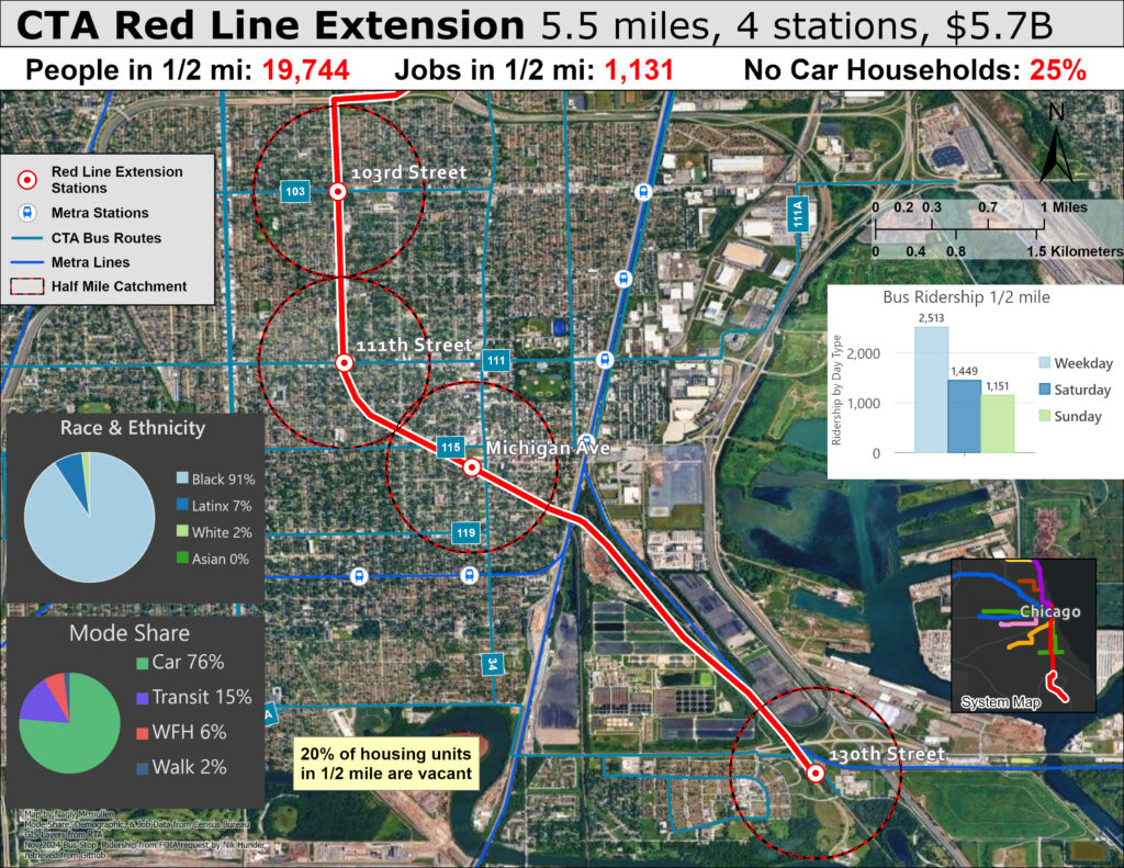
The broad overview of the extension shows an area that is not dense or transit dependent enough to merit rapid transit, even ignoring the massive cost. Less than 20k people live in walking distance of the 4 stations and there are essentially no jobs nearby. Abandoned homes are in abundance and nearby residential is predominantly single family. The area is mostly car dependent, seen with the high car mode share for commuting and limited density and bus ridership.
The predominantly Black residents will certainly have transit access improved and I would not want to dismiss transit’s role in increasing racial equity, but there are numerous majority Black and POC neighborhoods in urgent need of transit investment in Chicago, such as residents along the torturously slow west side Blue Line Forest Park Branch, which is completely falling apart and drastically needs a rebuild. The case for the RLE might be greater if the area was a transit desert, but as the map shows the area already has decent enough transit for such a far flung place. Several bus routes with decent service operate along the major corridors and already feed riders into the current Red Line terminus at 95th street. In additional, the Far South Side is already served by electric rail service with the Metra Electric Line seen nearby. Increasing service and reducing costs on Metra could have the same effect on improving transit access for a fraction of the cost.
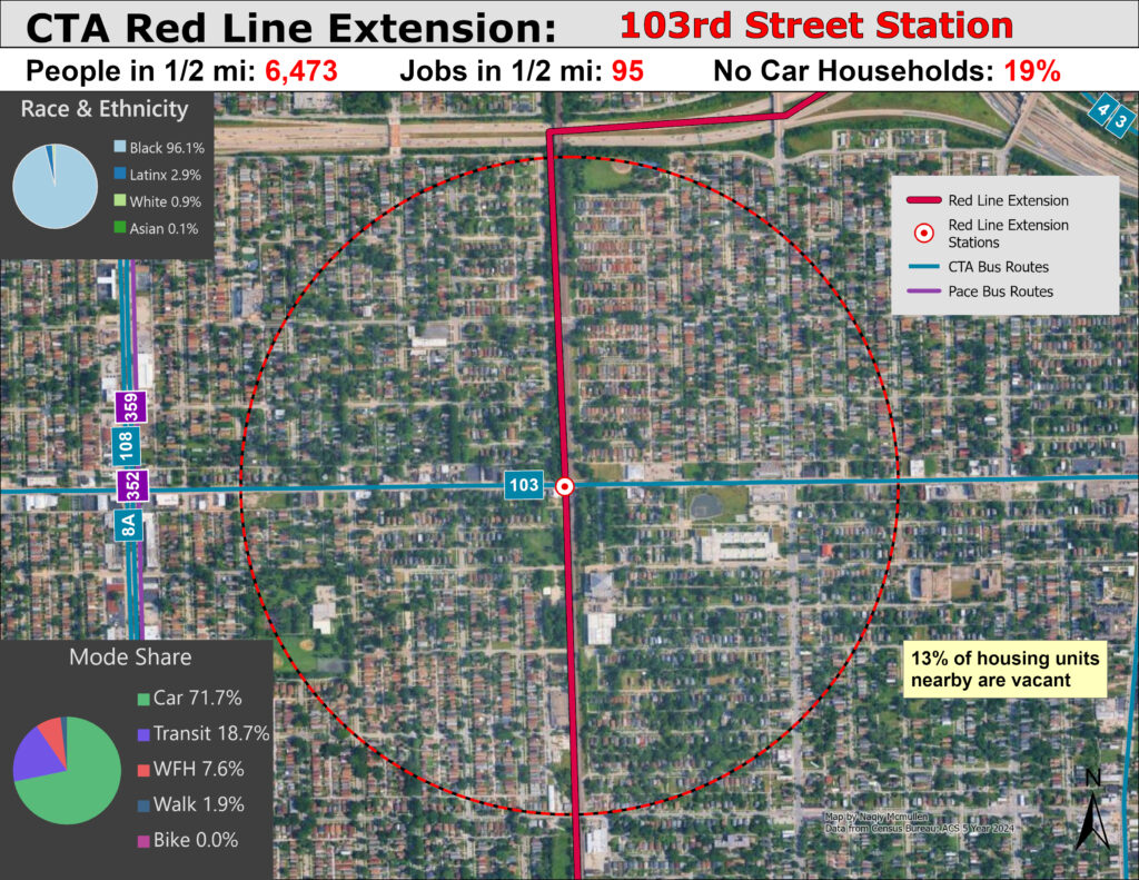
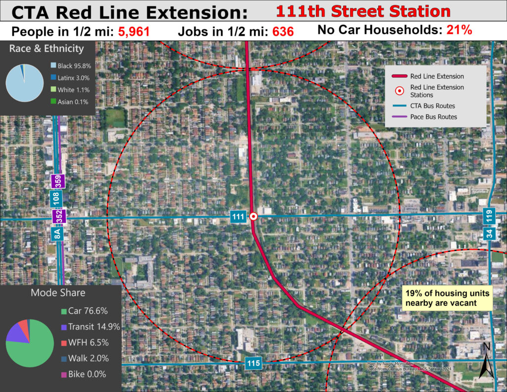
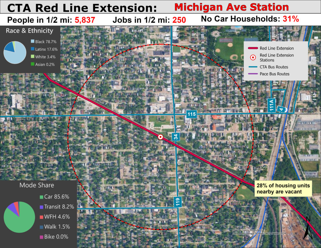
The image slideshow below provides a more granular look at each station’s surrounding land use, further reenforcing the negative observations induced by viewing the entire project map.
Land use is bad and current transit is sufficient. The Red Line Extension is unlikely to generate either substantial new ridership or private investment to revitalize the areas. Transit riders in dense urban neighborhoods must make due with slow local buses without even any investment in Bus Rapid Transit on busy corridors which have bus routes that serve many more people than this new extension. No matter how many jobs it creates or how long it has been promised, the RLE is a wasted opportunity that will do nothing to improve the greater Chicago system.
What is particularly frustrating, besides the wasted billions and years in lost time, is that CTA has abandoned several L branches over time that if existed today or rebuilt would likely provide more value than this project, simply looking at the abandoned lines catchment areas from a geospatial perspective using factors that typically denote transit propensity. My next post maps the abandoned branches L that existed in the past to examine the current land use around these lost stations, showing how it was a mistake to mothball these lines. While past leadership was more myopically focused on cost cutting above all, it is still sad to think about the value these lines could have provided in a city starved for fast and frequent transit service.