The first section of Los Angele’s highly anticipated D Line Extension along Wilshire Boulevard opened yesterday, a culmination of decades of planning, politicking, and finally construction. Three new stations — La Brea, Fairfax, La Cienega — opened to riders who had waited, in some cases, their entire adult lives. For a city defined by its freeways and its skepticism of trains, it was a genuinely strange and wonderful moment. But the miracle wasn’t the engineering. It was that the thing got built at all. The Wilshire Corridor has long been the route most conducive for rapid transit in Los Angeles, with plans for a subway underneath the highly significant street dating back to the early 1960s.
While a comprehensive overview of exactly why it has taken so long to open the first phase of the most critical rail route in LA is beyond the scope of this article, a quick summary will provide important context for understanding the forces that continue to stymie the success of transit in the broader Los Angeles region.
The story of how Los Angeles almost never built a subway under its most important street is a story about the specific, exhausting ways that American cities can fail themselves — through NIMBYism, political cowardice, bad luck, and the occasional methane explosion.
65 Years, One Boulevard, Endless Fights
In 1961 City planners first proposed a “Backbone Route” — a subway running the full length of Wilshire from Westwood to Downtown, with an elevated extension to El Monte. It looked visionary. It never got funded. In both 1968 and 1974 voters rejected transit sales tax funding initiatives. T
Finally in 1980 voters approved Proposition A, a half-cent county sales tax for rail construction. Tom Bradley, the mayor who had campaigned on a subway to the sea since 1973, had his funding. The Red Line project broke ground in 1986. Unfortunately the construction was a disaster. Cost overruns exploded into legal battles between Metro and its general contractor. A sinkhole opened up in Hollywood and became an instant symbol for everything wrong with the project. And then, in 1985, a gas leak caused an explosion at a Ross Dress for Less near the Original Farmers Market, killing no one but frightening everyone.
That explosion gave Congressman Henry Waxman what he needed. He pushed through federal legislation designating the area around Fairfax and Third as a “methane zone,” banning all tunneling through it. The ban was drawn carefully — running through exactly the neighborhoods where opposition to the subway was strongest. The Wilshire alignment was effectively strangled. Planners rerouted everything north under Hollywood Boulevard instead. The Red Line, eventually renamed the Purple and then the D Line, reached its western terminus at Wilshire and Western in 1996 and stopped there. It would stay stopped for two more decades.
Then in 1998 came the finishing blow. County Supervisor Zev Yaroslavsky — himself a longtime opponent of the Wilshire subway — sponsored a ballot measure banning the use of Proposition A and Prop C sales tax dollars for any subway tunneling in the county. It passed with 68% of the vote. The subway was dead. Legally, financially, politically dead.
The slow resurrection
What saved the Wilshire subway, in the end, was traffic. Specifically, the kind of grinding, soul-crushing, hour-to-go-five-miles traffic that had become the defining experience of life on the Westside by the early 2000s. The Metro Rapid bus that ran along Wilshire was operating at capacity. Something had to give.
In 2004 The LA City Council passed a motion requesting a repeal of the tunneling ban. The MTA board voted to reopen discussions. Mayor Antonio Villaraigosa won his election in 2005 with a transit vision at the center of his platform, and he gave the project a slogan that stuck: “Subway to the Sea.” It was a political phrase more than a literal plan, but it worked — it gave people something to rally around.
Then, improbably, the congressman who had created the methane zone ban changed his mind. 2005 Henry Waxman, after a peer review panel concluded that tunneling through the area could now be done safely with modern techniques, championed the reversal of his own legislation. 2007 The ban was formally lifted in December 2007 as part of the federal omnibus spending bill. One by one, the political obstacles were falling.
Funding came through Measure R in 2008 and Measure M in 2016 — two county sales tax measures that gave the project a dedicated, long-term financial foundation. Beverly Hills mounted opposition over the tunnel route passing beneath Beverly Hills High School, and that fight dragged through the courts for years. But it didn’t stop the project and finally in 2014 the long awaited Wilshire Subway broke ground on 2014.
Understanding the long journey that led to the D Line opening is crucial to understand the joyous celebration that occurred with local residents and national transit fans who rapturously descended on the three new stations. Many attendees were sporting T-shirts sold by LA Metro themselves urging residents to “Ride the D“, a viral marketing move utilizing the new train line’s namesake in a cheeky double entendre that readily appealed to young LGBTQ riders, a vast segment of transit devotees.
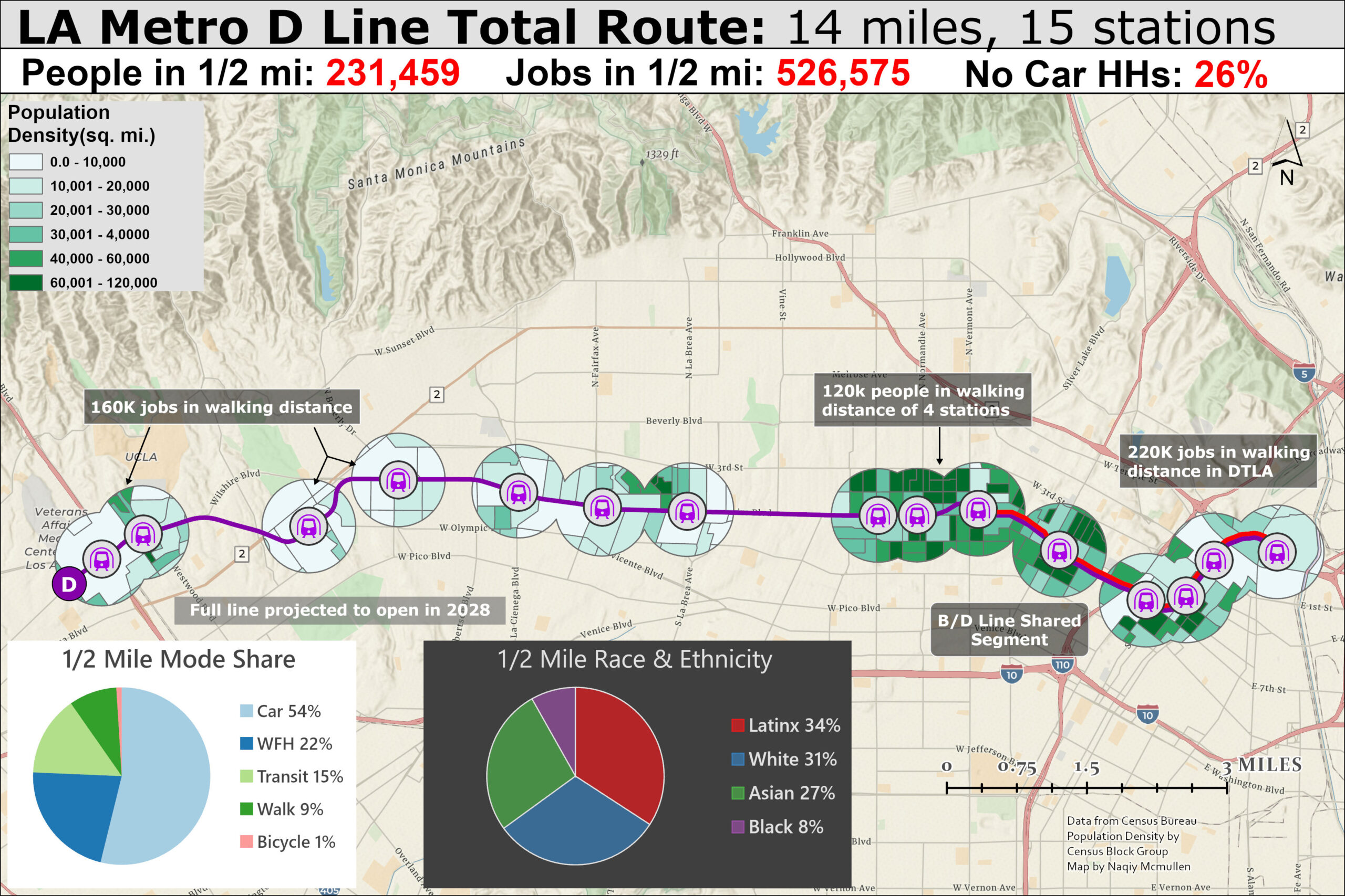
But the celebration and acclaim from transit advocates would not be so massive if the line itself was not so vital for LA’s overall transit plans. Many LA Metrorail extensions have opened in the past without nearly as much fanfare. The joyous festivities were not only because of the long wait, but also because how important the line is itself. Looking at the maps I’ve created calculating jobs and population near stations — essential elements for generating transit ridership — shows why this route when complete will be the cornerstone of the entire LA rail transit system.
A good start, but subpar land use, walkability, and service levels pose problems for future success
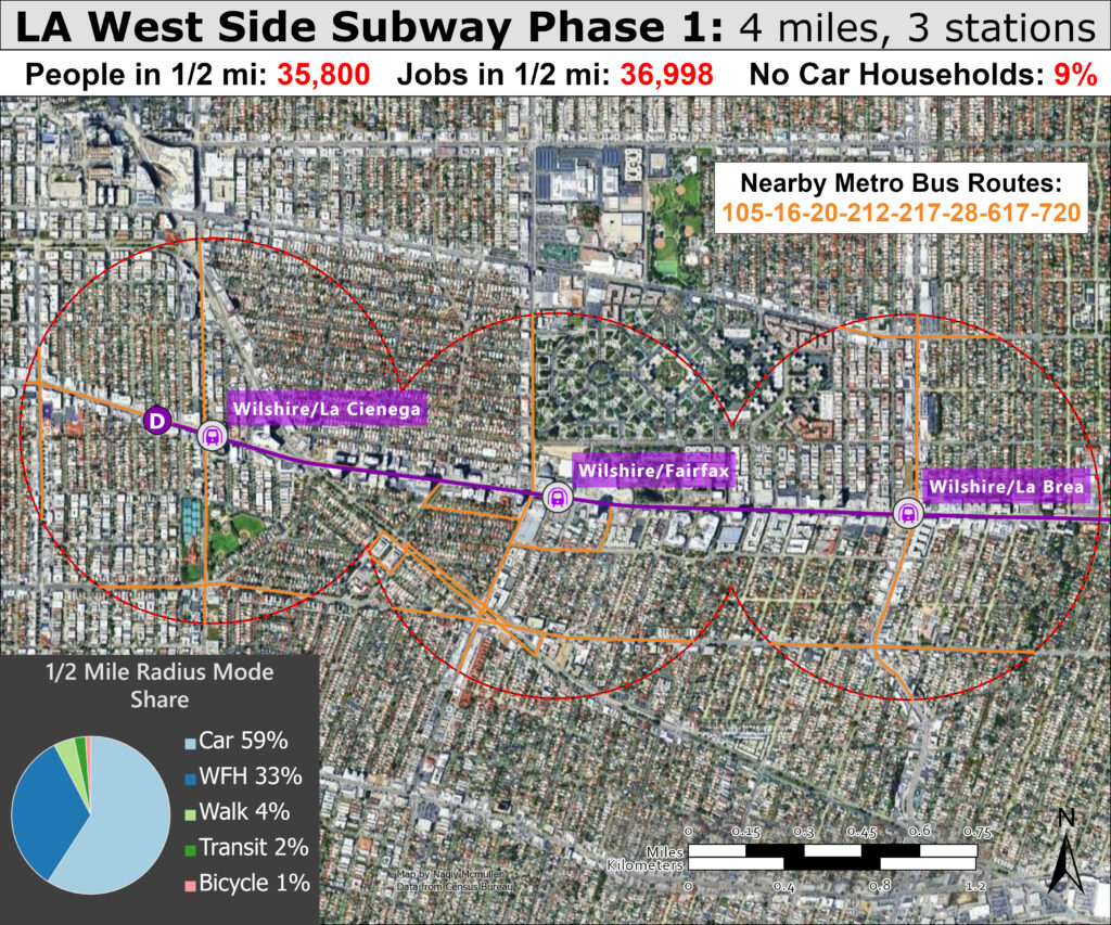
The map above shows the first three stations that opened today, providing a quick ride to the Los Angeles County Museum of Art, the premier cultural institution in the region, as well as an abundance of amenities along Wilshire. However, the modest residential and employment figures within a 1/2 mile catchment area of the stations is indicative of a potential problem that might lead to underperformance of the route. While Wilshire itself has both commercial and residential high density land use, the streets behind the urban canyon quickly decline into low density single family homes occupied by wealthy folks less likely to take transit. For the D Line to live up to it’s full potential the entire neighborhoods surrounding the stations must be upzoned and built up to adequate density worthy of a subway.
In addition, some of the biggest attractions live the Grove shopping city are about a mile away— outside the distance considered walkable, especially in the pedestrian hostile streets of Los Angeles which are typically very wide and full of fast cars not accommodating of pedestrians. Many destinations will require a bus transfer to complete the last mile of the journey. The many frequent and high ridership bus routes along the north-south axis will act as feeders, providing transit riders a quick transfer and much faster trip along Wilshire. But for the D Line to be considered a success it must do more than simply pull riders from the extremely busy 20/720 bus route— it must lure new riders outside the typical demographic of LA transit riders who are typically very low-income. Attracting more professional high income riders to have a vested interest in the success of the system will put more pressure on leaders to improve service and make transit a more attractive option for all.
Outside of mediocre land use and automobile focused streets, one major issue with the new route as well as other Metrorail lines is the poor frequency by rapid transit standards. Day headways are every 10 minutes which is already the floor for transit to be truly show up and go, but even worst are night headways which reduced to only every 20 minutes, making it not a true viable option for late night transportation. Most people with options will likely resort to rideshare rather than put up with the long wait. While the shared segment of the B/D line has trains every 5 minutes at peak and every 10 off-peak due to interlining, this segment is short. LA Metro should commit to increasing late night service to every 10 minutes all times like in the past and offer later spans of service to making riding Metro a smart and dependable choice for recreation as well as traditional commuting.
The next phases will provide the true value of the route
While the first segment of the route will quite possibly underachieve ridership predictions due to the aforementioned issues and LA’s continued struggle to regain riders lost over the pandemic, the full line will inevitably be a major success, meeting and exceeding expectations regarding ridership and travel times and the next two maps explain why.
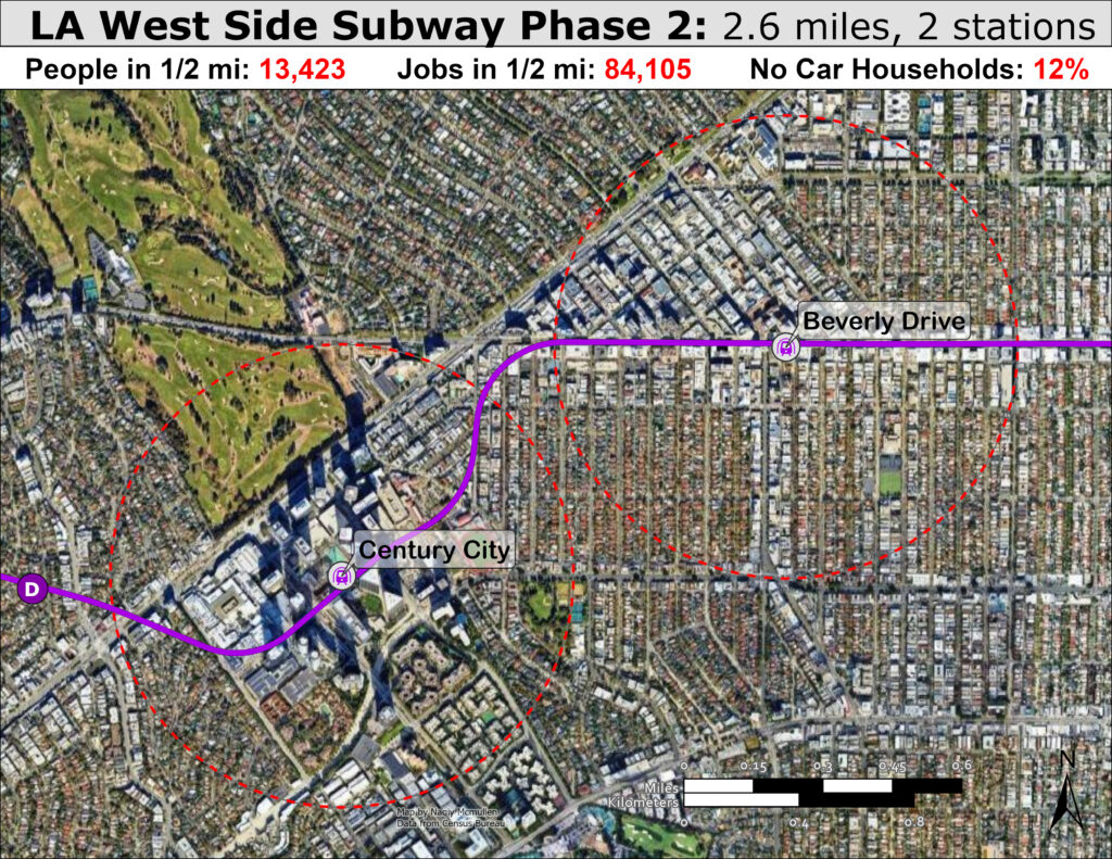
The next section to open will likely deliver the greatest ridership and value for LA by connecting with two dense, vibrant urban centers with an abundance of jobs, retail, and dense residential acting as trip generators.
The intensive land use can be easily seen in the satellite imagery with the two distinct cores standing out. Rodeo Drive and Beverly Hills are known for luxury shopping and upscale amenities which might not seem like an area conducive for transit ridership but the large concentration of retail jobs and limited parking will make rapid transit an attractive option for many.
However, the crown jewel of D Line will assuredly be the prime location right in the middle of Century City. This dense secondary CBD was developed on the former backlot of 20th Century Fox and its first building was opened in 1963. The collection of skyscrapers forms a distinctive peak in LA’s multifaceted skyline, containing many corporate offices (one which famously used as a filming location for Die Hard) as well as high rise residential buildings. in addition, there is a popular mall right next to the station, notorious for issues with parking. Even through a sizable segment of the Century City catchment area contains a golf course, the high density land use and interminable traffic congestion are poised to make rapid transit appealing to even steadfast drivers.
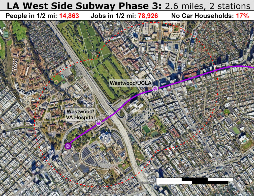
The final segment has a guaranteed high ridership station with the UCLA location seen above. Universities are known trip generators for transit with college students more likely to use transit as well as universities being large job centers. UCLA has the largest enrollment in the University of California system, with many students likely to use the D Line when it opens for class or general transportation purposes. Although the station itself is not centrally located on campus, it is still close enough to serve the students well, although the steep grade from being located on the edge of the Santa Monica Mountains might pose a potential problem, overall the university is primed to provide a healthy of ridership to the D Line. The future Sepulveda line, currently in the planning and design stage, will increase the utility of the station and route even more when opened.
Missed opportunities
The VA Hospital station likewise serves an employment center and a segment of society more included to use transit, although the surrounding land use is not optimal, rerouting local buses to stop here will provide a helpful terminus for navigate the West Side of LA on public transit. The planned D Line terminus can be viewed as a painful miss opportunity; in initial planning stages the the project was often referred to as the Subway to the Sea and was planned to continue down Wilshire all the way to Santa Monica.
This final phase of the project was descoped to save money by planners to figured Santa Monica was already getting sufficient transit with the E Line light rail that opened in 2016. The decision to eliminate D Line segment to Santa Monica is emblematic of poor decision making and political priorities that have plagued Metrorail from inception.Constructing an extension to Santa Monica for the D Line will be much more expensive than if it was included as part of the original D Line project, making such a project unlikely to occur with greater transit needs around the vast region.
The need to spread around scarce transit capital dollars, the driving factor in canceling the extension to Santa Monica, is a critical flaw in the funding mechanism of county regional transit funding initiatives. To win votes, leaders promise ineffective suburban rail extensions instead of simply building rail in the dense core neighborhoods most in need of rapid transit.
This has resulted in the longest light rail line in the world, the A Line, which continues to open little used stations further and further to the east when these capital dollars would be better utilized in the core, or barring that simply improving the region’s commuter rail MetroLink instead of building slow competing lines. Without these ineffective extensions it’s likely the regional sales tax funding LA Metro would not pass, especially considering the California requirement that tax legislation must obtain 2/3 of voters instead of a simple majority. So they perhaps can be viewed as a necessary evil, but continued construction of low performing lines ultimately provides ammo for conservative transit critics who contend transit is a waste of tax money(few conservatives would ever criticize ineffective road construction of course).
Ultimately we need smarter and more effecting planning and engineering to reduce costs and improve value, although that is beyond the scope of this blog. Seattle is another region facing the consequences of building long and low performing light rail lines instead of focusing on dense core neighborhoods with their various Sound Transit plans approved by voters. Seattle and LA are essentially the only regions with massive rail plans and both places must focus on routes serving the densest areas with the highest ridership potential if they want the cities to increase transit mode share and ultimately become more sustainable and prosperous.
Moving on from that tangent, the construction of the Sepulveda Line, a project that is second only to the Wilshire Subway for ridership potential and regional transportation important, would slightly diminish the need for a Santa Monica D Line extension by providing a quick connection to the E Line, as seen in the project map from Metro below. However this project is not even close to breaking ground and has seen headwinds from wealthy NIMBY’s with influence with current Mayor Karen Bass, although local advocates are fiercely fighting for this pivotal project to move forward. For the good of the entire Los Angeles it is critical the project does not experience the same delay that stymied the Wilshire Subway for so long.
The full extension — all nine miles to Westwood, with stops at UCLA and the VA campus — is expected to open by fall 2027. A trip from Union Station to Wilshire and La Cienega that once took 45 minutes by car will now take 21 minutes by train. Mapping the entire route highlights the value of the full project that will be fully realized when complete. The D Line connects the two largest employment centers in the region between the West Side and DTLA. In between the job rich business districts are some of the densest neighborhoods in the city in Koreatown and Westlake. While LA deserves criticism for its car centric development patterns and sprawling suburban land, the historical core has always been denser than common perception but has lacked high quality rapid transit necessary create walkable, transit oriented neighborhoods. With the D Line nearing completion, a future where LA is not primary perceived through the lenses of a windshield is perhaps in sight.

Closing Thoughts
One relatively short line will not suddenly change LA into an urbanist utopia no matter how fast and frequent, especially in such a massive sprawling region, but seeing the line finally reach fruition is a marker of the political progress the region has made to support necessary transit investments. Zev Yaroslavsky, critical force in the decades long delay, was seen celebrating the success of the project along with numerous other leaders and residents, a paradigm shift for how public transit was viewed in the past. LA should have ideally been building rapid transit in the 1960s when federal funding for transit was at its peak and the complete modern rapid transit systems like BART and WMATA were built with 90% of the tab picked up by the federal government, but it is still applaudable that they are essentially the only city constructing a massive new rapid transit system and hopefully in 20 years, the Sepulveda transit project, K Line North to West Hollywood and Light Rail line to Artesia are all in operation and the central city finally has enough rail transit to make it a viable option for all residents, even those who can afford to drive.
However, while lack of rail service in the core is a central problem with the regional transit system, the issues go beyond what can be fixed with the projects currently in LA Metro’s capital plan. One huge issue is the regional fragmentation of the system due to the immerse amount of municipalities in LA County and an overall lack of effective regional rail and transportation options for navigating the massive multipolar region. Future posts will delve into these topics. Los Angeles is a fascinating topic for urban discourse, and using geospatial analyst, data science, and historical literature review we can better understand the second largest region in the US.
Key Links to read more about the D Line extension