Introduction
This article examines the census tracts with the highest transit commute rate in every state using 2023 American Community Survey(ACS) 5-year estimates. Tracts were filtered to have a minimum of 1000 workers to remove outliers with few residents or commuters that were not broadly representative of the overall population.
The post attempts to analyze the attributes that correlate with high transit usage as well as illustrate different transit dependent neighborhoods across the country, especially in states without dense urban areas. The map below provides a national look at the data, with states with the highest transit modal share tracts echoing conventional urbanist wisdom, largely tracking the states with the largest and highest density cities, although the highest tracts themselves offer some surprises, delivering unique insight into transit ridership and commuting patterns The peak rate is mapped nationally below, and the core commuting data is available to explore in a Google spreadsheet here and the complete list can be viewed on an ArcGIS Online app here.
Census Tracts Mapped
The main section of this report examines the tracts mapped using GIS software to show a satellite view of the land use associated with the high transit modal share. Relevant demographic attributes are included in the map images and a discussion of the various factors and areas of interest in the study area is given below each map to provide relevant context and interesting facts and information not included in the map itself. The maps are posted below in descending order matching the table above. This is the first in a series ranking the first 10, with the rest to be written up and posted in subsequent weeks.
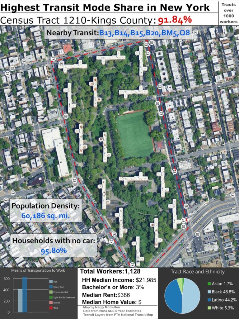
#1 New York:
New York City has the census tract with the highest percentage of transit commuters, which is the least surprising conclusion from this study. The tract itself might be somewhat of a surprise, located in far east Brooklyn in the Cypress Hills neighborhood, the tract consists entirely of a large public housing development, The Cypress Hills Houses, and does not have particularly great transit by NYC standards. It is directly served by several bus lines, as well as the Euclid Ave subway station on the IND Fulton Ave line several blocks to the north just out of the sight of this map. The Euclid station is served by the A express train and the C local train. While this level of service would be phenomenal for any other city, simply having a subway station nearby is not notable by the city standards, even with an express stop.
The real reason for the high transit usage for the tract, as you can probably discern, relates to the demographics of the residents. NYC is the only city with a sizable portion of residents in public housing, with only half a million people in the NYCHA projects scattered throughout the 5 boroughs, many of which look similar to this development. The public housing contains extremely poor folks, as shown by the household median income of barely over $20,000. The tract is also extremely segregated; it is only 5% white and is composed of predominantly Black and Latino residents. Overall, these factors are the primary reason it has the highest mode share for transit in the city and country. The low income residents are unable to afford automobiles unlike wealthier residents in the far flung outer boroughs, only 4% of households own a car, and do not have white collar employment that allows for WFH like many professional positions are allowing for in the post pandemic era. In addition land use also plays a part.
The towers in the park, featuring high density housing surrounded by empty greenspace, is an example of modernist development that has since fallen out of favor but was a model used for many public housing developments in the era when public housing was still being built. While originally theorized to have a positive effect by surrounding residents with greenery and space for recreation, these surrounding areas were never well maintained and were a negative element by reducing vibrancy and street life and did not integrate into the surrounding community well. The empty underutilized space also reduced walkability and nearby retail, reducing nearby employment opportunities. While dense by US standards, the tract is not particularly dense by NYC standards, another byproduct of the underutilization of the space surrounding the towers.
The numerous neighborhoods with excellent transit and multiple subway lines throughout NYC also typically have a larger concentration of jobs nearby, allowing people to walk to work and reducing the transit mode share. The residents of this tract have no choice but to take transit; however they are lucky to live in a city with great public transit that allows them to live car-free without causing severe quality of life concerns.
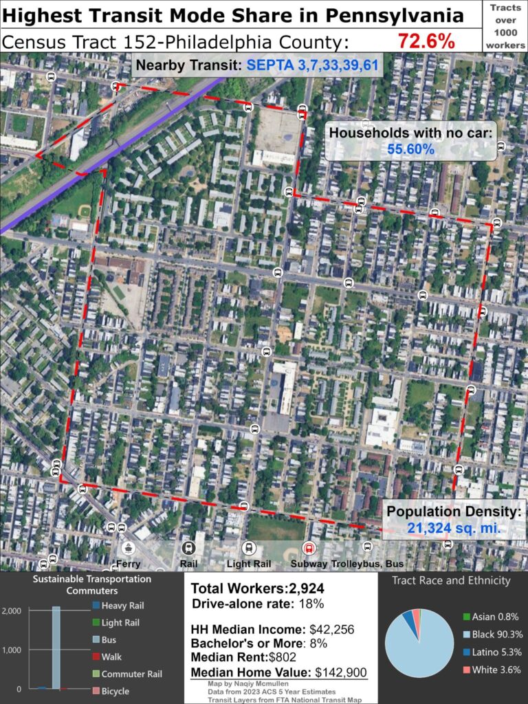
#2 Pennsylvania
Philly has the second highest transit mode share tract as a dense, diverse, and historically transit oriented city. As one of the few cities where transit is a viable transportation option, it is such a shame that state leaders have failed to fund SEPTA, leading to severe service cuts following the fiscal cliff that threatens numerous transit systems around the country,
This tract in North Philadelphia West is almost completely Black and has a mixture of affordable and market rate housing. It is still very low income overall but median income is still double the previous tract. The eastern edge is about half a mile from the Broad Street rapid transit line, but the majority of transit riders use the multiple bus routes serving the tract to commute.
The housing typology is majority vernacular Philly rowhouses along with an ample amount of duplexes and a smattering of single family houses and medium size apartments. It is not particularly dense although it has enough population density to support high transit ridership along with the traditional street grid. It has underutilized land and several empty plots are visible in the satellite imagery, signifying the rampant disinvestment present in Black urban neighborhoods across the nation.
The tract is also relatively far from downtown or any notable job centers, so walking is not a viable option similar to the previous tract. This tract is part of an extensive trend in this map series of demographics being a driving factor behind high transit usage rather than quality of service or population density.
#3 Massachusetts
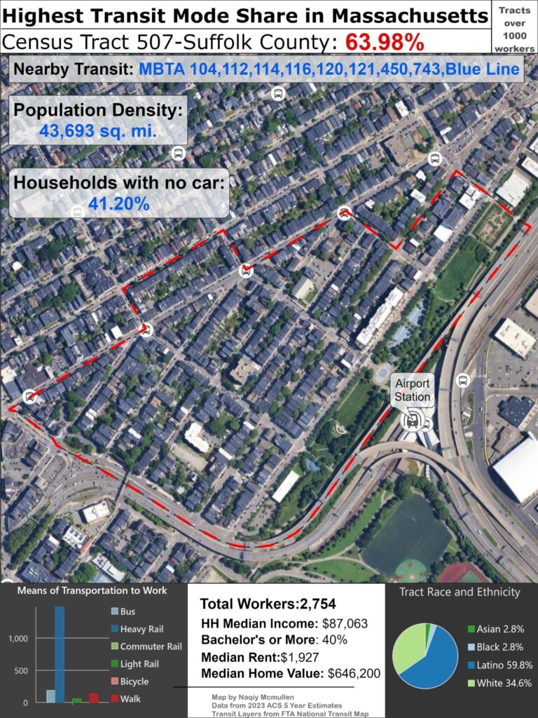
This tract in the East Boston neighborhood with the highest transit use in Massachusetts is far different than the previous two tracts. It is not extremely poor, although its household median income is still $34,000 below the Boston median HH income, a testament to the city’s success as a wealthy innovative service economy backed by a highly educated workforce. This tract is just across the Boston Harbor from Downtown and is also adjacent to Logan International Airport. The Blue Line, a short rapid transit route which has the notable attribute of using both third rail and overhead catenary for electrification, has a station right on the edge which moves the majority of workers in the area. It is also served by several bus routes.
The tract is completely enclosed by water features, a highway, and the nearby airport, making walking a less tenable option despite its proximity to the CBD. The historical development patterns of Boston such as small streets and limited parking makes transit a preferable mode of transportation especially to the CBD, even though the majority of households own an automobile. The tract is majority Latino, and East Boston is the center of the fast growing Latino community in Boston. While demographics likely play a part in the high transit mode share, access to high quality transit and spatial factors are a larger determinant than the previous two tracts we examined.
Although the tract is not extremely poor, the extremely high housing costs in Boston and lack of affordable housing, seen in the high home value and median rent being far above the previous two tracts, are a serious issue facing the community and city as a whole. With an average home value of $650,000, a household would need an annual income of almost $200,000 to afford home ownership, far beyond the tract and city’s median wage.
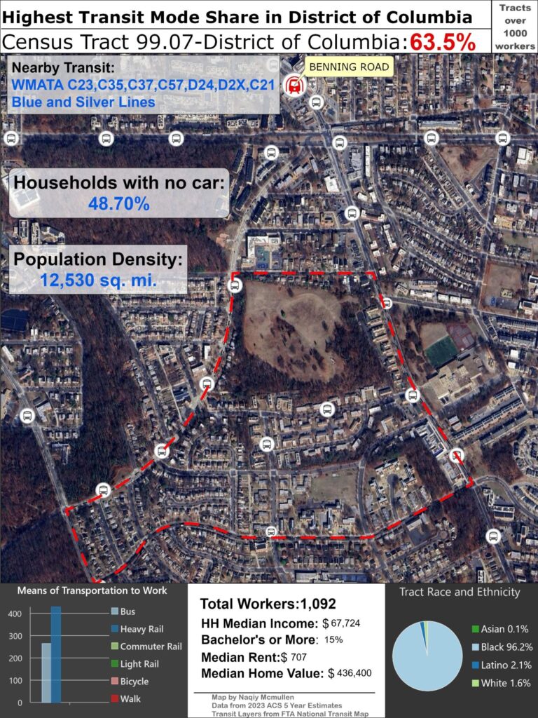
#4 District of Columbia
This DC tract, while unfairly not a state, is demographicly similar to the first two tracts with an almost entirely Black population and a far lower household median income than the overall average of $107,000. Located in the Benning Ridge neighborhood in the southeast quadrant, it is surrounded by greenspace and is almost entirely residential, making walking to work a nonviable option. The cemetery at the top of the tract takes up a substantial amount of space, lowering the effective tract density, but overall the tract has land use typical of the neighborhoods east of the Ancostia, with a mixture of townhouses, duplexes, and small and medium size apartment buildings. The tract has decent transit with a metro station just outside the tract boundaries with service from the Blue and Silver lines and numerous bus lines feeding riders to the rapid transit station.
#5 California
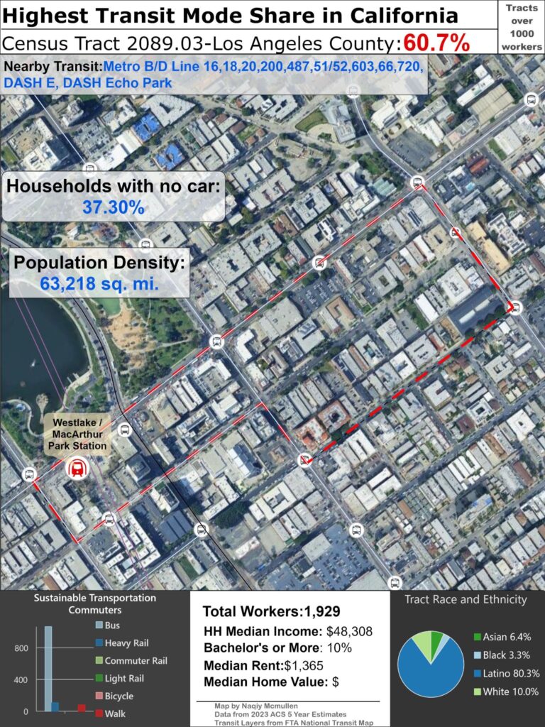
Despite the mostly true common perception Los Angeles as car dependent sprawling hellscape, it does have some notably dense, walkable and transit orientated areas in the urban core. LA having a tract with a higher transit mode share than the peaks in distinguished urban locales like San Francisco and Chicago is empirical evidence that the city of angels is not completely hopeless in its urban sphere. While the high transit mode share is mostly related to its demographics similar to the previous tracts, it is not possible to have such a high transit mode share without having decent transit options, and transit being the majority transportation mode for work trips despite the majority of households having access to a vehicle indicates there any many so called choice riders taking transit because it provides a viable alternative, not simply because of poverty. There are many poor and predominantly Latino census tracts in this country that are not lucky enough to have access to viable transit to forgo the financial burden of car ownership.
The tract is directly served by heavy rail with a B/D line station, however the majority of commuters use the numerous bus lines in the area, such as extremely frequent rapid 720 line, underscoring the current limitations of the LA rail network and the region’s reliance on slow buses as the backbone of the transit system. However, the number of rail riders could increase as the Wilshire subway extension into the job-rich west side is set to open its first phase any month now.
The tract has among the highest population density in the city, located in the Westlake neighborhood in the dense and historically urban Central LA region. Urbanists often equate LA with broader Los Angeles county or more suburban areas of the municipality like the Valley to slander the city and the Sunbelt as a whole, but Central LA, full of dingbats and historic courtyard apartments, is an equally vital part of the local heritage and cultural narrative as the sprawling single family neighborhoods and mansions in the hills that form the prototypical image of LA.
While this tract is not an urbanist paradise by any means, even the densest parts of LA like this neighborhood are typically hostile to pedestrians and transit riders with wide high traffic arterial streets and inadequate sidewalks and pedestrian infrastructure, it counters the popular adage “no one walks in LA”. Plenty of folks walk and talk transit here, people just do not see due to windshield bias. As LA continues to expand its rail network, hopefully high transit use areas like Westlake will become the norm instead of an outlier in the future.
#6 New Jersey
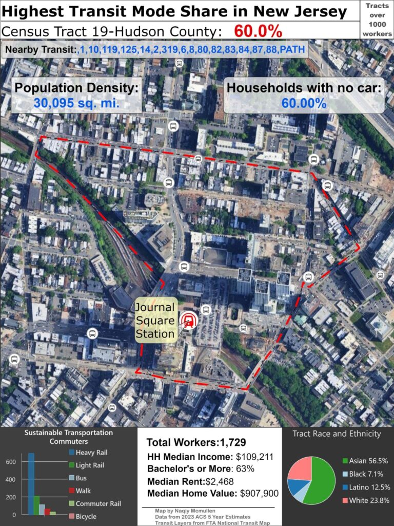
Jersey City is GOATed.
Jersey City is one of the fastest growing urban areas in the country due to its rapid transit connection to Manhattan and a pro-growth policy that allows ample dense transit orientated housing compared to the miniscule amount produced in NYC. Displacement from rapidly rising rents in the city continues to compel people to seek cheaper housing across the Hudson and Journal Square epitomizes this rapid vertical growth in JC with numerous residential skyscrapers built in the last decade and more under construction.
The demographic attributes driving high transit ridership are in stark contrast to the preceding tracts, with high income workers commuting to professional white collar positions in Manhattan likely making up a large portion of the transit commuters here. The high median income and highly educated population provide a glimpse of a demographic segment that rarely takes transit at such a high rate in most US metropolitan areas, further emphasizing NYC’s special status as the only truly world class city in the country.
While Jersey City and Hudson County as a whole clearly benefit from their role as the unofficial 6th borough, they are great urban environments on their own accord and deserve just as much attention from city nerds as the more famous urban landscapes across the river.
The area is served by a PATH station directly in the center of the tract which accounts for the majority of transit trips in the area and is the catalyst for the booming real market in the station catchment. The majority of transit commuters use the Hudson Tubes likely to travel to Manhattan, although downtown Jersey City and downtown Newark are also possible destinations on the short PATH system as respectable job centers.
Light rail is the second largest mode of transit riders; although the Hudson Bergen Light Rail does not serve this area, riders likely connect via PATH to their final destination as the ACS only allows users to select one mode in their survey response.Riders using commuter rail as their means of transportation to work are likely connecting as well, although there is a chance they are referring to PATH as well because it is legally classified as commuter rail and regulated by the FRA because it uses mainline rail ROW and runs in close proximity to the NEC in some segments; the FTA however classifies it rightfully as Heavy Rail. Few folks use buses to get to work, reiterating the professional nature of this tract’s workers, and since Journal Square is not an employment center few people walk to work either.
Demographically this tract is quite diverse with a majority of Asian residents;Journal Square is home to a large Indian enclave and New Jersey overall is the state with the largest percentage of Indian residents.
#7 Illinois
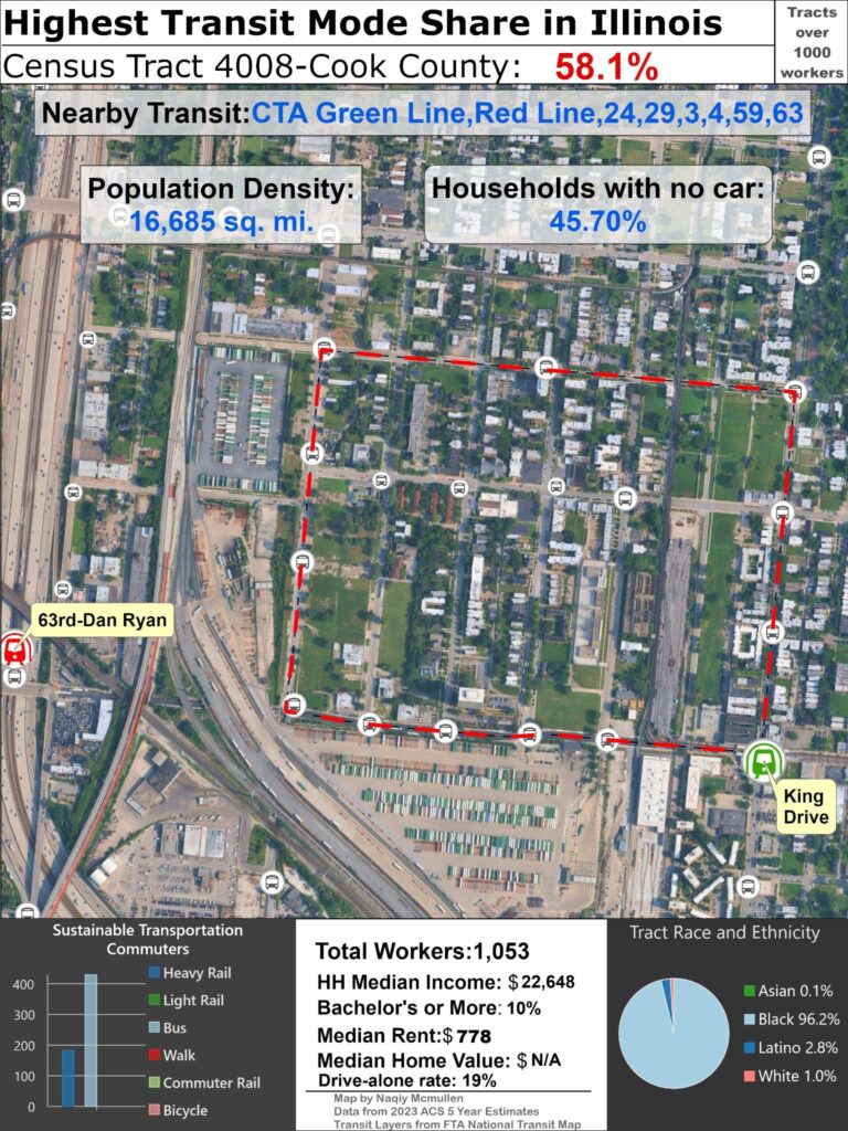
Chicago is a great city (disclaimer: I live here) with probably the second best transit system in the US in aggregate; although WMATA is definitely superior if just comparing rapid transit, but Metra and CTA buses are better than their DC counterparts. However; the system has some serious problems in scope and utility that is apparent by the low state ranking, and the severe fiscal crisis that devastated SEPTA will soon cause equally awful service cuts to Chicago’s transit services if not addressed soon. The potential destruction of transit in the city is embarrassing and shameful considering Democrats have a large majority in the state legislature. The L is a cultural icon second only to the Bean in national recognition and letting it fail should simply not be an option yet leaders seem apathetic and ignorant to the value transit has for Chicago, anchoring the largest employment center outside of Manhattan in the Loop. This entry will be lengthy to give some greater perspective on my local transit system so bear with me.
Aside from the fiscal cliff the current system is not living up to its potential for a variety of reasons and has some inherent design limitations. Chicago is a large dense city that is unfortunately exceedingly car-centric in most neighborhoods and the radial rapid transit system plays a large part why most folks drive to work and Mayor’s often proclaim Chicago is a car city to justify supporting the status quo. The L largely designed to move people in and out of the CBD, great for white collar workers but less helpful for working class residents in lower paying positions sprawled across the city.
This dichotomy between white collar workers using rail and low wage workers using buses which better serve the geography of the retail and hospitality industries that profit off the nonunionised labor is seen in this tract—the majority of workers use buses to commute despite the nearby Green and Red Line L stations. This tract like so many in this series has a high transit mode share not because of excellent transit but simply because of demographics, with the tract exceedingly poor and almost entirely Black, a legacy of the intense disinvestment and segregation in Chicago’s South Side. It is located in the Washington Park community area, which has lost over 50,000 residents since 1950, and is just a few miles west of the prestigious University of Chicago and the educational enclave of Hyde Park.
Other systemic issues with Chicago transit can be seen with the Red Line station, poorly situated in the median of the Dan Ryan expressway. Chicago was an era adopter of building rapid transit in the middle of massive highways which is unfortunately still a practice to this day; although heavy rail essentially stopped getting built after the 70s the scourge of highway rail lives on with many light rail lines utilizing highway ROW to the detriment of riders. While it can be argued bundling rapid transit highways is a necessary evil to reduce costs, the downsides are too immense to ignore. A rail station surrounded by a highway has limited opportunity for TOD, forcing rail lines to rely on bus feeders for most ridership. Additionally waiting for a train in the middle of a highway with ample noise and air pollution is extremely unpleasant, especially when dealing with unreliable and infrequent service. Over ¼ of the L track mileage and 23 out of 146 stations are in an expressway median. The radial service, inconvenient connections between lines, poor land use, and unreliable service afflicting the L has led to ridership that is only 60% recovered it prepandemic peak and vastly underperforms its potential; it has half of the per mile ridership of the much smaller T in Boston for example.
Other issues with Chicago transit are familiar ones plaguing almost all US transit. The vast mainline commuter rail system METRA is well utilized by suburban commuters but fails to live up to its potential as a massive regional rail system due to lack of downtown through running, Metra has 4 downtown terminals, high fares, and insufficient stations in city limits to cost cutting closures by the previous private operators. This tract for example had a station on the current Rock Island District line until 1978, which was served by three intercity rail companies in addition to commuter rail at its peak. Numerous commuter rail stations were closed across Chicago to speed suburban commuters to the city center, although lack of fare integration and more expensive fares compared to CTA despite traveling over the same distance would likely mean most residents would forgo the service even if the station still existed. Failure to transform expansive mainline rail infrastructure to modern regional rail like so many other countries is an issue harming the potential of transit in all US legacy metropolisies and I encourage readers not familiar with the problem to read more on the topic by local transit advocate Starline, who has created a realistic and transformational plan for regional rail by building a downtown tunnel to connect several METRA lines together. Metra is a vast system with relatively good night and weekend service by US standards, but it should aspire to be a great regional system like the RER or German S-Bahns.
One of Chicago’s biggest urban assets is its massive traditional street grid and the accompanying bus network which means almost every resident in the city is within walking distance of a relatively frequent bus route and indeed bus ridership exceeds rail ridership. However the city is far too large to rely on slow local buses as the backbone of a transit system and this flaw is indicative of transit’s failure to compete with the private automobile as a primary mode of transportation for most residents, especially considering the failure to speed up buses by building bus lanes, BRT, and other transit priority infrastructure, as well as closely spaced stops. Chicago has the potential for a truly great transit system with enough ambition and tenacity, but at the moment the risk it becomes much worse is far greater unfortunately.
#8 Washington
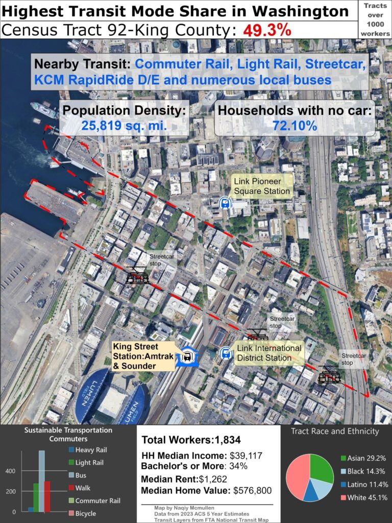
Seattle has the most ambitious transit projects under development after Los Angeles currently, although the sprawling suburban extensions to placate voters and rapidly rising construction costs threaten the viability of the core city rail lines with the most ridership potential.
This tract, overlapping with the Pioneer Square neighborhood and Seattle’s Chinatown, is directly south of Seattle’s CBD, illustrated in the amount of people walking to work slightly exceeding light rail commuters. It has two stations on the rapidly expanding Link LRT system just outside its boundaries, as well as the mainline King Street station, the terminus for two Sounder commuter rail lines, which also has intercity rail by Amtrak with six daily round trips to Portland, two daily trains to Vancouver, and a single daily long distance train to Los Angeles. The tract also has several streetcar stops on the First Hill line which are limited in utility like most US mixed traffic trolleys- this one largely hindered by the failure to advance a connection between this line and the South Lake Union Trolley which would have created a useful 5-mile line out of the two current short segments.
Despite the plethora of rail options, this tract like most has bus riders as the largest segment of transit users. Luckily Seattle has a pretty good bus system with a large fleet of articulated vehicles operating frequently including an extensive trolleybus network which are well suited for the steep slopes of the city. Seattle also has a good regional bus network although it is not relevant for discussing this tract.
Demographically, this tract like so many others in this list has a much lower median income than the city, although the area is gentrifying due to its proximity to the job-rich downtown. It also has a large homeless population like many west coast cities due to extremely high housing costs and several shelters in the vicinity. It is approximately similar to the overall city racial and ethnicity demographics, but slightly more diverse and slightly less white overall. Its population density is high by city standards, with midrise apartments composing the entirety of the housing stock; while less dense than other core city tracts, its effective density is brought down by two highways and the waterfront industrial areas taking up land.
While this tract appears to be in line with other poor high transit mode share areas discussed, it also contains many professional downtown workers using transit and is a true transit dependent dense and walkable neighborhood seen by the low rate of car ownership. Seattle is perhaps the only city urbanizing and vastly improving transit with its mostly grade separated light rail system, and this tract is an example of the numerous transit options available in the city.
#9 Wisconsin
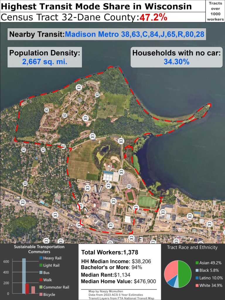
Wisconsin might be known nationally most for dairy products and alcoholism, epitomized best by drunk Green Bay Packers fans wearing large hats of cheese, but it actually punches above its weight for urbanism with its two only cities Milwaukee and Madison being quite dense and walkable by US standards. Milwaukee has lost population like most Midwest cities but never hollowed out like so many and still has a good collection of cheap walkable neighborhoods.
Madison, the featured city here, however is booming and continues to add residents rapidly every year along with greater Dane County. While much of the growth is sprawl on the onskirts, the urban core continues to rapidly densify as well due to its location on an isthmus and no urban highway through downtown, incentivizing denser development near the vibrant state Capitol area and large well regarded University of Wisconsin. The core is extremely walkable with a very successful pedestrian mall, and has a great collection of cycling infrastructure.
While transit service has lagged behind its wonderful walkability and bikeability, a recent bus route redesign, launch of the first BRT line in a planned network, and the hiring of famed transit expert Christof Spieler as the city’s Director of Transportation hopefully are positive steps that hopefully transform the system into one that excels as a valuable transportation option able to adequately serve the dense city core as well as the more sprawling suburban areas.
This tract however has such a high transit mode share for the simple reason it is composed entirely of the university campus and nearby student housing. Students are the largest user of the Madison Metro, and the system really only adequately serves the campus areas. The low median income indicates typical broke college students but these students will mostly go on to be very successful and wealthy. An urbanist cliche that often goes viral is that people remember college fondly because for most Americans it is the only time they live in a dense walkable environment and this tract spotlights this statement extremely well. Although the nominal density for this tract is extremely low due to the ample greenspace and numerous college facilities, the isthmus as a whole is extremely dense close to the campus and the State Capitol building.
There is not much else to say about this tract, although I intend to write more in length about the successful pedestrian mall State Street and surrounding dense areas in a post ranking the surviving US pedestrian malls.
#10 Maryland
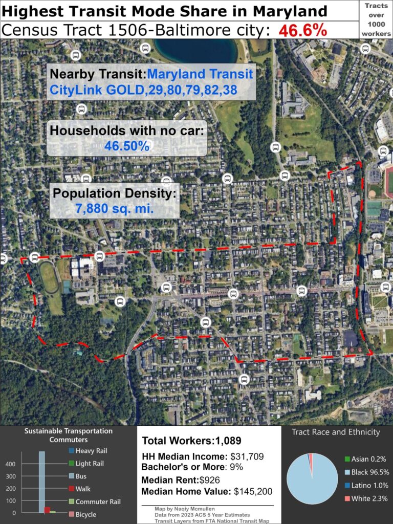
Baltimore is another city with unheralded urbanism that is unfairly slandered by racist Republicans. It has the unfortunate fate of being located along the NEC which has the greatest collection of cities in the country so its multitude of relatively dense and walkable neighborhoods are largely ignored by national urbanists. The majority Black city is an easy target for fascist fearmongering when they aren’t too busy attacking larger cities like Chicago. This tract is similar to many others as a poor almost entirely Black area that commutes almost entirely by bus. Baltimore has a better than average bus system due to the large percentage of residents without access to a car mostly due to poverty, but transit supportive land use and housing typologies in the urban core due to the historic age of the city merit better transit service than the currently provided.
Baltimore does have both light and heavy rail, but both systems were poorly planned and constructed using cheap ROWs that misses most of the density in the city, resulting low ridership compared to the bus routes. The fact that this tract has no one commuting on either the Light RailLink or SubwayLink (I don’t understand the names either) but does have a few residents riding the commuter rail MARC, presumably to DC, shows the lack of value the current rail lines have. A badly needed east-west rail line, the Red Line, was extremely close to breaking ground and would have actually served important activity centers, but was cancelled by Republican governor Larry Hogan in 2015 to shift state funding to roads in a hateful rebuke to the city in need, an anti urban act of malice typical of Republicans. The plans have since been revived with the current Democratic governor but with federal funding for transit under attack by the car brained conservatives in charge it is unclear whether the latest version of the project will ever reach fruition.