In my previous post, I examined land use around the planned Red Line Extension, showing that the project costing almost $6 billion is a poor investment unlikely to generate significant ridership or value Chicago due to disinvestment and low density land use in the Far South Side. I believe it is a terrible use of limited capital funds, especially when there are so many greater needs for transit riders. To reenforce this point, I mapped land use around the numerous branches that were abandoned over time. Many of these served areas of greater density with more transit dependent residents than the planned RLE.
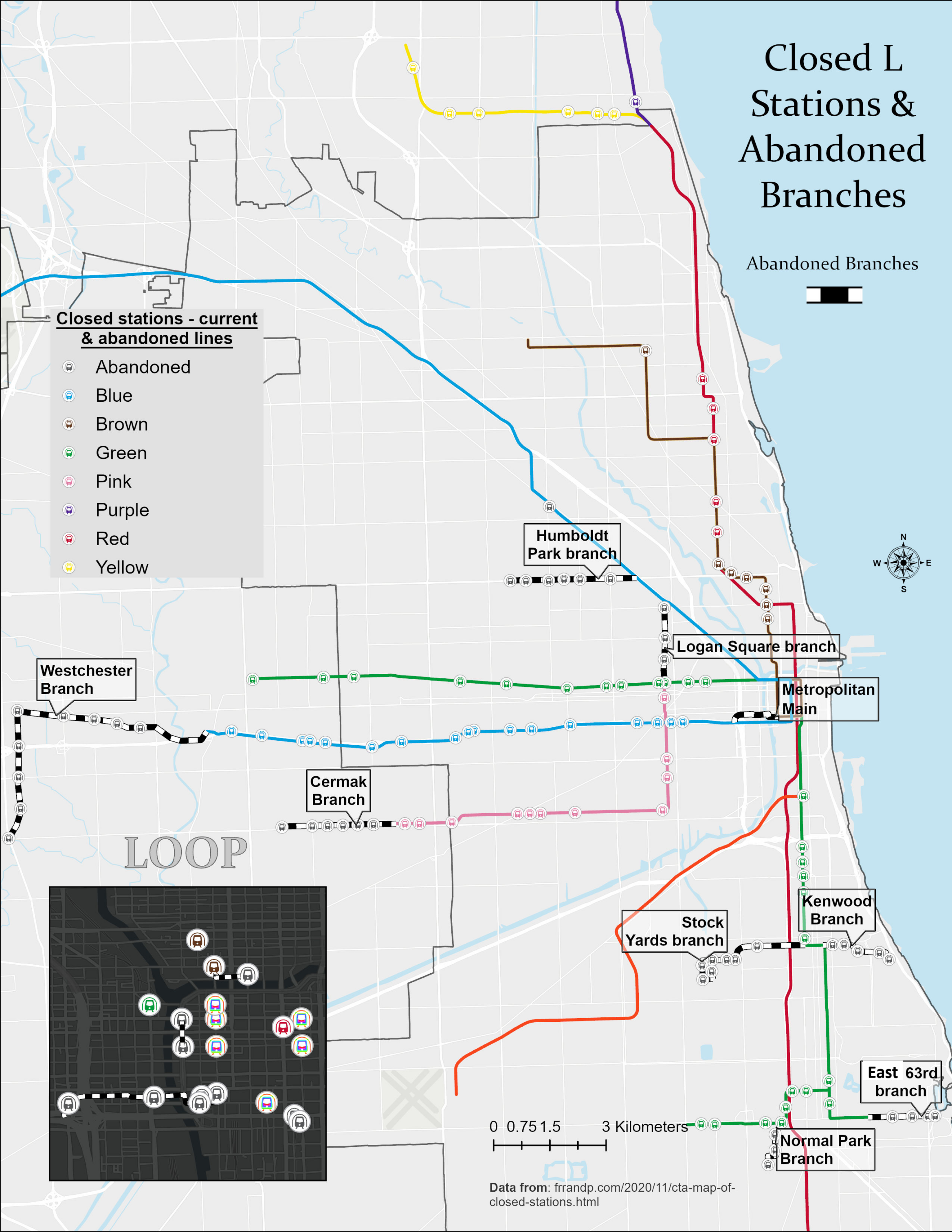
Below is a map of the abandoned branches along with abandoned stations on existing L lines. Many of the stations were closed for cost saving measures and to speed up service because of the closer proximity to others stations, although several could provide real value today and CTA has been rebuilding some closed recently. The NITA Act actually mandates reopening a Central Ave Station on the Blue Line in Austin, closed in 1973, as well as a new Englewood station on the Green Line. The map does not include the Garfield Park branch, demolished to build the Eisenhower Expressway and replaced with the Blue Line in the highway median, to the detriment of transit riders.
Also ignored in this analysis are the many commuter rail stations in the city that were closed by private operators before Metra was formed to speed up commutes for more profitable suburban riders. These closed stations had a great effect on reducing fast mobility for urban transit riders and rebuilding more Metra stations in the city would be perhaps the most cost effective way to add new rail service to many neighborhoods especially if Metra transitioned to a frequent regional rail operating model, another topic of conversation all together. For more information about efforts to expand and improve Metra, read StarLine’s extensive writings on the topic.
While many of these branches were short segments, they would still provide value to riders in the city over slow local bus routes. While most of the abandoned routes happened early in CTA’s history after they assumed control of private transit companies, the East 63rd branch ,also known as the Jackson Park branch, was abandoned relatively recently in 1997. This is an especially short sighted decision in retrospect considering it would have served the newly opened Obama Center, which is leading a wave of revitalization in the area. We will start with that branch mapped below.
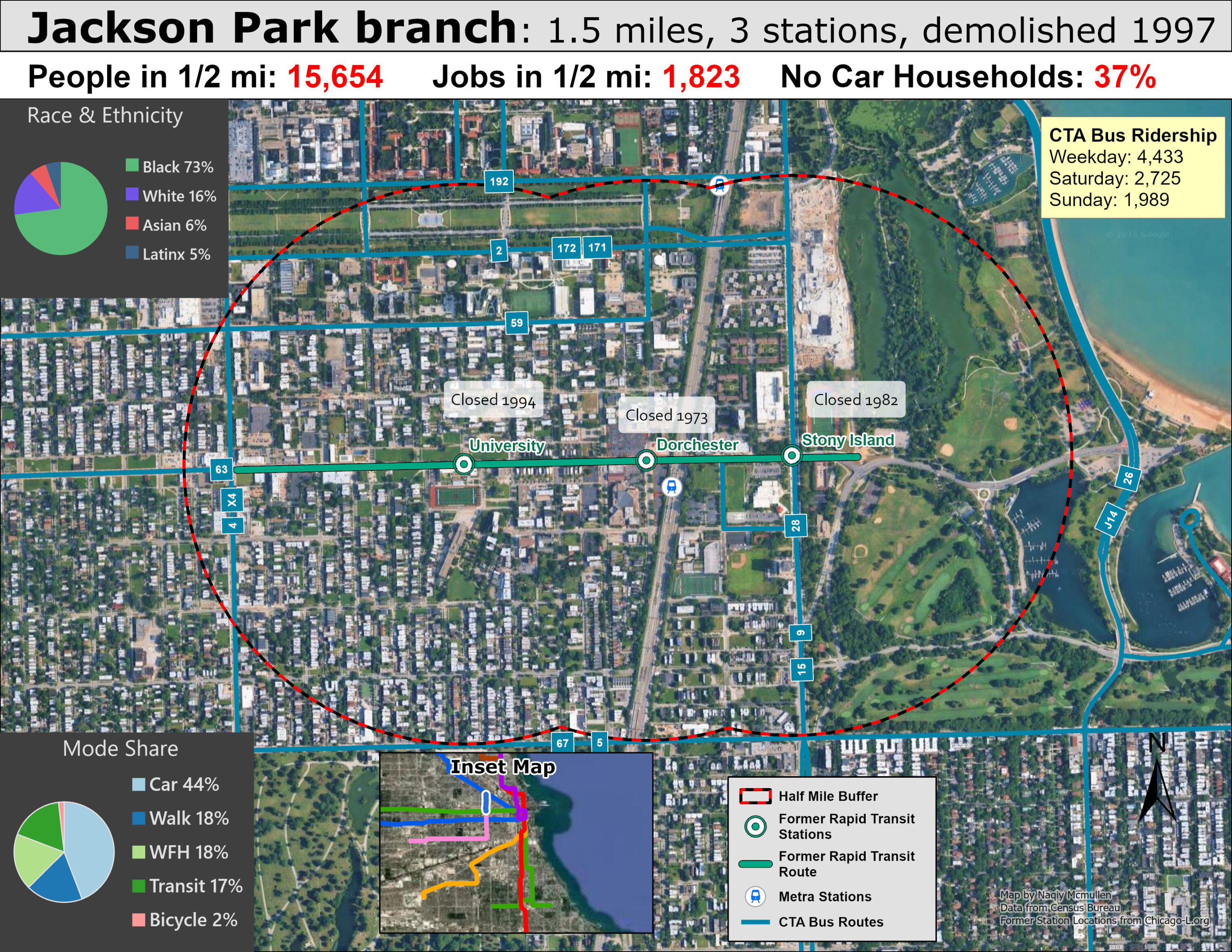
One of the worst decisions made in recent decades regarding Chicago transit is especially sad because its ultimate demolishment arose from community members who believed the elevated structure was decreasing property values and revitalization efforts in the area. A privileged pastor, Bishop Arthur Brazier of the Apostolic Church of God, led the charge to get the dilapidated rail line demolished instead of properly repair after it it had sat crumbling for several years. Supporters of the rail line believed that the Brazier and other leaders calling for demolishment intended to profit off redevelopment of the vacant land. Unfortunately the Pastor and his co-conspirators were more politically connected than the transit riders and community members who supported repairing the Jackson Park Branch. While community leaders have generally become more supportive of transit in the recent decades, with calls to rebuild the abandoned branch to connect with Metra and the Obama Center, nothing has come of it so far.
The branch was originally built to serve the 1893 World’s Columbian Exposition: the famed world fair that introduced Chicago to the world for the first time. The 1893 Expo was also infamous for the sadistic serial killer that preyed on attendees, covered in the essential Chicago history book, The Devil in the White City. The branch dropped riders off mere steps away from the fair in a temporary terminal that demolished shortly after fair concluded, but the rest of the branch lived on to serve riders for decades. Despite the green space taking up a substantial portion of the catchment area, the land use has an abundance of multifamily residential nearby. While the area is well served by busy bus routes, a one seat ride on graded separated elevated transit is always preferred over transferring and the severed Metra-L connection is a great loss.
The Green Line gets far less ridership than the Red Line, and if rebuilt this branch would likely not generate substantial ridership at first, but the potential for new TOD is greater than the RLE because of the proximity to Hyde Park, University of Chicago, and the new Obama Center, all of which offer far greater urban amenities than the Far South Side. The residents are also more transit dependent than residents of the Far South Side, as well as predominantly POC. Taking into consider the network effects of a convenient Metra Electric (which serves the Far South Side) Green Line connection, it is very plausible that this project would have a greater effect on racial equity via transit construction than the RLE for a fraction of the cost.
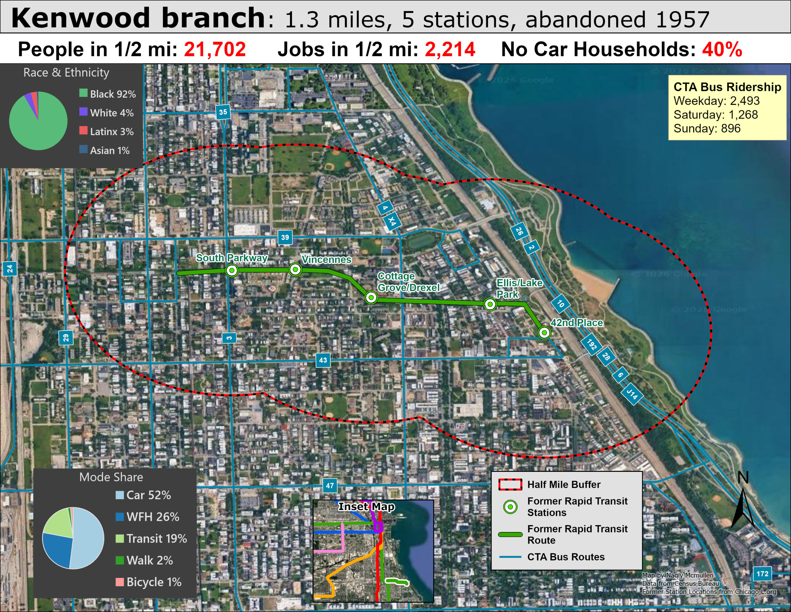
Another South Side branch that was abandoned, this one just north of Hyde Park and the University of Chicago serving the nearby neighborhood of Kenwood.The Kenwood branch’s roots actually predate the “L” itself. It traces back to 1864, when the Union Stock Yards and Transit Company built a freight line paralleling 40th Street, which by 1882 was also carrying passengers to various stations. The branch as Chicagoans came to know it was born out of a 1903 city ordinance requiring grade separation along that corridor. The South Side Elevated took over passenger operations while the Chicago Junction Railroad built the elevated right-of-way, and the two companies signed a 50-year lease in 1903 that would prove fateful decades later. Construction delays pushed the branch’s opening to September 20, 1907, running from Indiana station east to a terminal at 42nd Place and Oakenwald Avenue, mostly on a solid-fill embankment shared with freight tracks. The line spurred real development along the way — developers built elegant new apartments along Drexel Boulevard and converted single-family homes into multifamily housing to meet demand from new riders.
The branch’s slow death began with money troubles, not ridership. During the Depression, the Chicago Junction Railroad, as owner of the line, deferred maintenance, and a long-running rent dispute with the elevated company ensued. When the CTA inherited the line in 1947, it quickly concluded the Kenwood route had no real future and could be more cheaply replaced by buses now that the CTA also controlled the surface system. By the mid-1950s the branch was running as a shuttle with deteriorating stations and aging wooden cars, and the Chicago Junction’s demand for $100,000 in annual back rent — against CTA operating losses already running $200,000 a year on the line — sealed its fate. Mayor Daley brokered a temporary reprieve at token rent, but ultimately low ridership, high renovation costs, and the rent dispute caused the branch to close for good on November 30, 1957, when its original 50-year lease expired — fittingly, the same closure that removed the last wooden elevated cars from CTA passenger service. Much of the embankment still stands today, a quiet relic of a line undone by economics rather than any catastrophic event
This is another short rail branch that if rebuilt would serve an area with land use more conducive towards transit ridership. The population is more transit dependent, it much closer to the Loop and other important transit trip generators, and the nearby housing is denser than on the Far South Side. Rebuilding this short segment would be another hypothetical alternative project to deliver greater transit access and transportation equity to a majority Black neighborhoods on the South Side that would also likely be cheaper than the costly RLE.
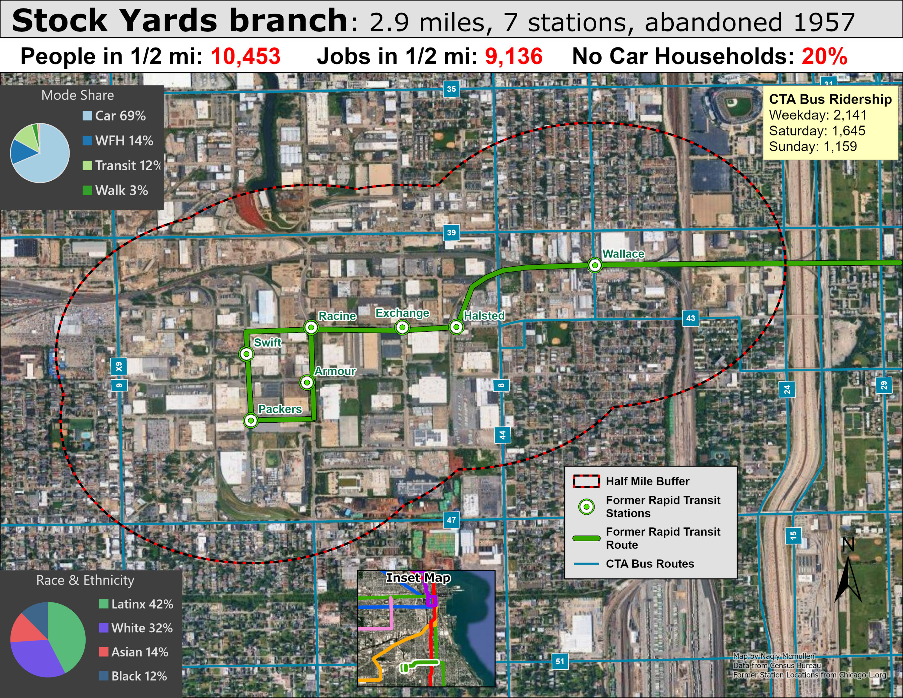
The Stock Yards branch was a rarity among Chicago’s “L” lines: it existed to serve a single industry. Its roots trace back to 1864, when the Union Stock Yards and Transit Company built a freight line paralleling 40th Street, and by 1882 that line was carrying passengers too. A 1903 city ordinance requiring grade separation along the corridor brought the South Side Elevated into the picture, and the branch finally opened on April 8, 1908, running 2.9 miles west from Indiana station in a single-track loop around the “Packingtown” section of the yards, built as a conventional steel elevated structure so it could snake around the stockyards and clear the Chicago Junction’s freight tracks below. On opening day alone, 25,000 people rode it — many just curiosity-seekers — and the South Side Elevated even ran newspaper ads promoting Stock Yards tourism. The line’s real purpose, though, was hauling laborers: roughly 50,000 people worked in the Yards, giving the branch a steady built-in ridership for decades. Its history wasn’t without disaster — a 1934 fire that started with a careless cigarette butt tore through the Yards, destroying the Halsted station and a trapped two-car train, and severing the branch in two for months — but the line and the industry around it pressed on regardless.
The branch’s demise tracked the Yards’ own decline rather than any flaw in the “L” itself. After World War II, the rise of the interstate highway system and refrigerated trucking let meatpackers relocate to cheaper rural plants, bypassing the stockyards model entirely, while rising urban land values and anti-pollution laws made staying in Chicago even less attractive. Major packers like Armour and Swift began planning their exits, starting with Wilson and Company in 1955, and since the branch existed solely to connect the main line to the Yards, there was no case for keeping a line whose rent exceeded its fare revenue once the Yards started shrinking. Despite another serious fire damaging the loop in 1956, the CTA actually repaired it and reopened in April 1957 — only to shut the entire branch down for good on October 6, 1957, citing declining revenue and a poor outlook for future ridership. Today, almost nothing of the line remains; within the old yards site there’s no trace at all, and the broader Stock Yards themselves closed for good in 1971, with the area redeveloped into an industrial park.
Reviving a line like this today would look nothing like restoring 1950s service, but the corridor itself still has real potential. The old right-of-way runs through parts of Back of the Yards and New City — neighborhoods that, unlike the vanished stockyards they once served, are very much alive and currently underserved by rapid transit. A modern line along a similar alignment could cut commute times to the Loop and the Red/Green Line network, support transit-oriented development in an area with available land, and give the now-industrial park better connections for workers who don’t drive. While rebuilding this line does not provide transit equity to underserved Black communities on the South Side, it does serve a larger employment center than the RLE, with a decent amount of blue collar jobs still existing in the industrial area, albeit far less jobs than existed at the peak of the industry. The TOD potential is also far greater than RLE considering the closer proximity to Chicago’s job and amenity rich CBD.
Now we will move on to abandoned elevated routes on the west side of Chicago, starting with Humboldt Park.
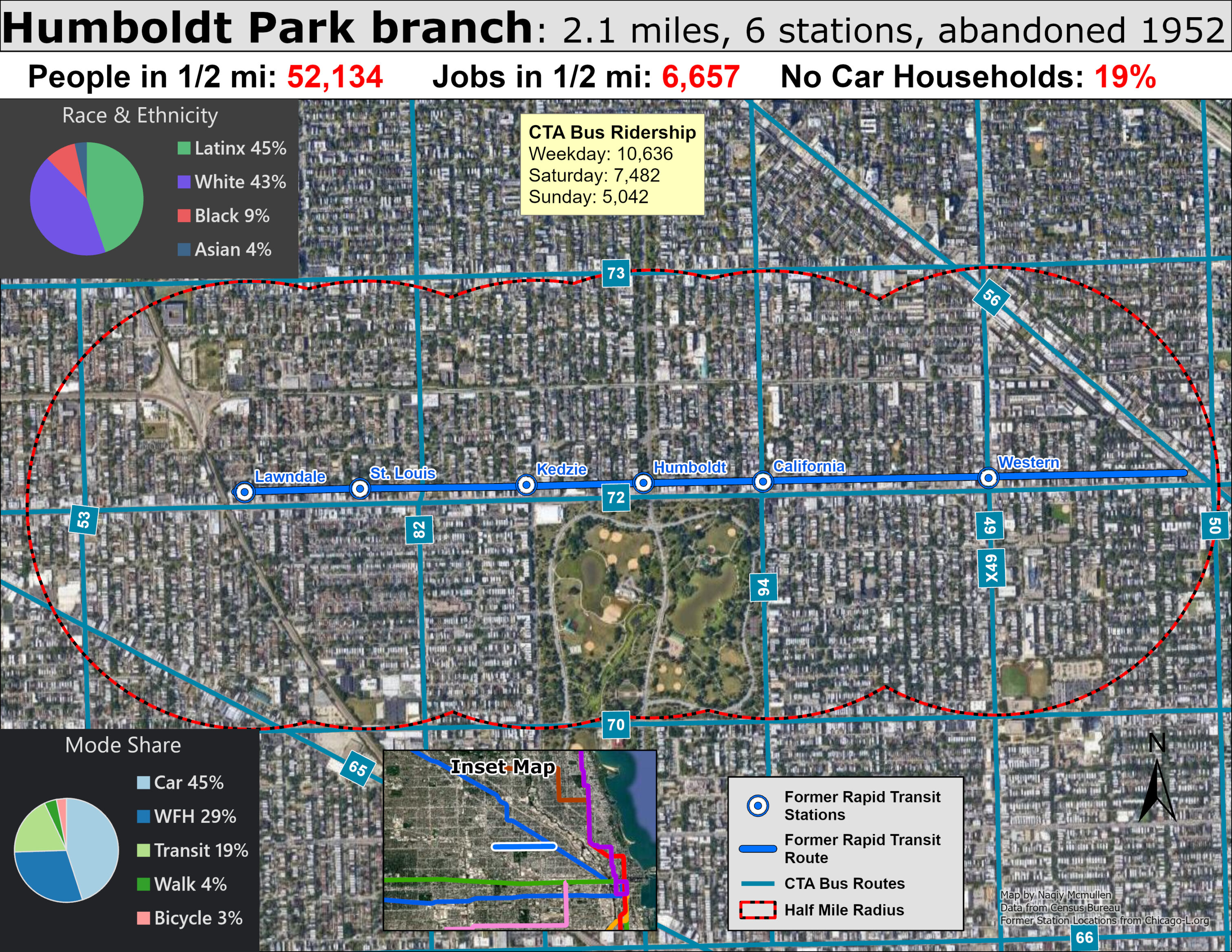
The Humboldt Park branch was born with bigger ambitions than it ever fulfilled. Built in 1895 by the Metropolitan West Side Elevated Railroad — Chicago’s third elevated company and the first to use electric traction — the branch split off from the Northwest branch and headed west along North Avenue, with plans to eventually reach 72nd (Harlem) Avenue, 6.5 miles out. That extension never happened, and the line instead settled permanently at a modest, out-of-the-way terminal at Lawndale Avenue, originally meant only as a temporary stop. The branch served its neighborhood reasonably well for decades — it had five original stations with the classic Met-style brick and terra cotta station houses, and a sixth, Humboldt Park Blvd., was added in 1902 after residents complained the existing stations were too far apart. Unlike its lower-ridership cousins on the South Side, the Humboldt Park branch actually had a healthier passenger base, drawing on the business district along North Avenue and the surrounding residential neighborhood — which is exactly why the CTA couldn’t just shut it down outright and instead resorted to a slow squeeze of service cuts.
That squeeze proved fatal all the same. The branch’s fundamental problem was that stub terminal at Lawndale, which had no real ridership draw, combined with running just a half block from a competing North Avenue streetcar line that simply ran more often. The CTA stuck Humboldt Park with hand-me-down wooden cars while pouring new steel 6000-series equipment into the neighboring Logan Square line in 1950, and ridership predictably drifted toward the nicer trains. The opening of the Milwaukee-Dearborn Subway in 1951 was the real death blow — it pulled Logan Square service into the subway, and since wooden cars were barred from subway operation, Humboldt Park was left stranded from downtown entirely and reduced to a shuttle. Local Alderman Geisler and local residents fought the closure with petitions and even a lawsuit seeking to block demolition, but a judge ruled the CTA was within its rights, memorably noting the agency could “do anything it pleases.” Service ended for good on May 4, 1952, replaced by the #72 North Avenue Limited bus, and the elevated structure was torn down in stages over the following years, with the last stub demolished in the late 1960s.
A modern Humboldt Park line would land in a very different neighborhood than the one it left in 1952 — one with strong, transit-starved demand along the Blue Line’s western edge. A rebuilt branch along North Avenue could finally give Humboldt Park and the surrounding West Side direct rapid-transit access instead of relying on buses sharing the same congested streets as cars, cutting commute times substantially for residents headed downtown. It could also spur the kind of transit-oriented investment the original line never got to deliver after its extension was scrapped — more housing density and retail clustering near stations, similar to what’s happened along revitalized sections of the Blue and Green Lines elsewhere in the city.
A dense diverse transit orientated neighborhood in the heart of the city, Humboldt Park is the epicenter Puerto Rican Chicago residents, surely deserves consideration for rapid transit as a formerly served neighborhood with potential to generate far greater ridership than the RLE. 50,000 people live near the former stations on the Humboldt Park branch and bus ridership averages over 10k weekday trips in the 1/2 mile radius near former stations. While the more intensive land use makes it a more complicated project than the sparse ROW readily available on the Far South Side, rapid transit to serve the dense urban neighborhoods closer to the Loop should be a priority overall sprawling suburban extensions far from downtown. This type of rail expansion has proven to be ineffectual and provide a poor return on investment across the country compared to serving urban neighborhoods that already have significant transit ridership and density to support further ridership growth and TOD investment.
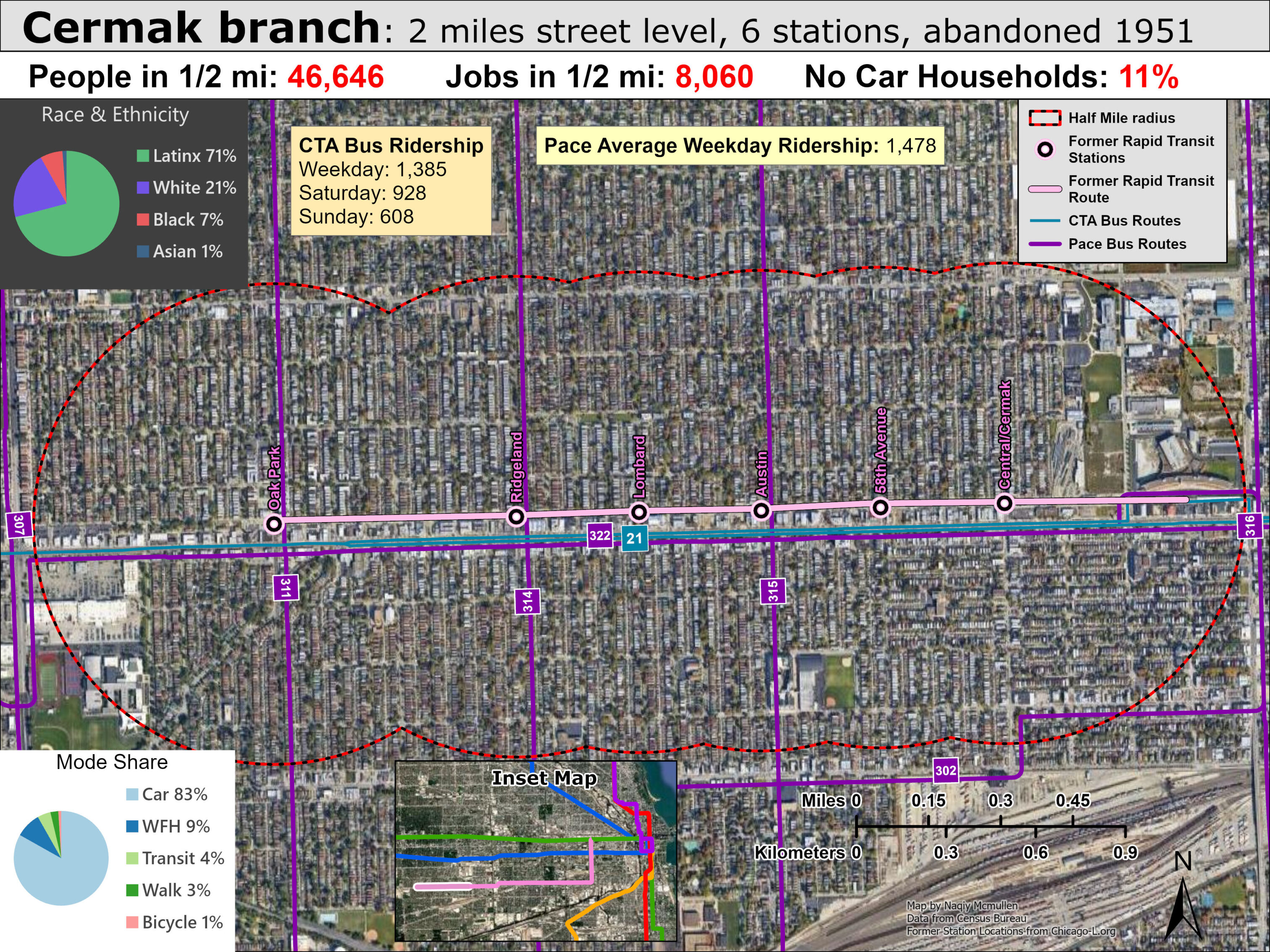
This short segment, part of the current Pink Line and former Blue Line Douglas Branch, this street level route was an easy choice for early abandonment and the former ROW can be easily seen on satellite imagery currently occupied by local business parking. The area is outside of city limits, encroaching into Pace’s service area and quite car dependent with minimal bus ridership and high car ownership. The Pink Link currently ends in the inner suburb of Cicero and the former route extended through it to the adjacent suburb of Berwyn. While far from the urban core of Chicago, the area surrounding the former branch has a mixture of medium density apartments and single-family homes occupied by primary Latinx residents; Cicero in fact is the most Hispanic municipality in Illinois at 89% with Berwyn not far behind at 64%.
While the ROW to rebuild this extension is still readily available, the current use as ample parking means residents and local businesses would undoubted object fiercely if such a project was ever proposed. While current bus service is fully capable of serving the corridor and connecting to the current Pink Line terminus, the amount of residents living with walking distance of the former stations further reiterates how sparsely populated the station catchments of the RLE are compared to most neighborhoods in the city and surrounding inner suburbs. CTA has long considered the domain to primary the city and has often underserved dense areas just outside city limits. While the RLE may be technically in city limits, the land use is far less transit supportive than many inner suburbs that CTA often leaves for Pace to properly serve.
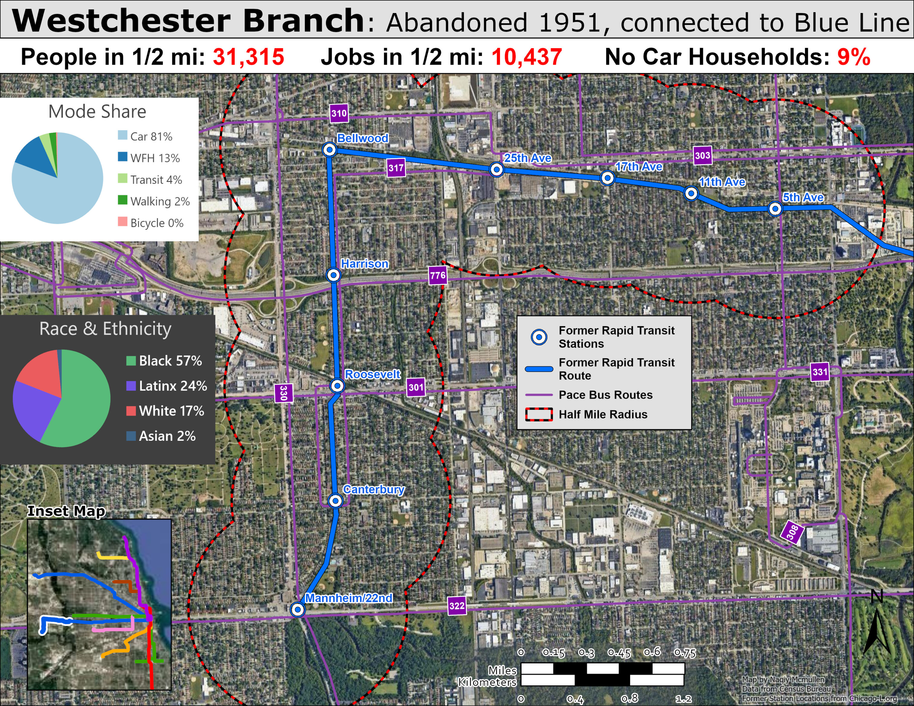
Another suburban west side corridor, this one lengthier but also even more car dependent than the previous example. The Westchester branch began life as a real estate play more than a transit necessity. In 1925, the Chicago Westchester & Western Railroad was organized to build a bypass route for the Chicago Aurora & Elgin interurban, leaving the CA&E’s main line at Bellwood, turning south to 22nd Street, then heading west — and the initial mile-long segment conveniently served a 2,000-acre tract of land owned by associates of CA&E president Thomas Conway, Jr., which was quickly subdivided and sold off to developers. Service began at 12:34am on October 1, 1926, operated not by the CA&E but by the CRT, which extended Garfield Park trains out to the new Roosevelt Road terminus. A second extension followed in 1930, stretching the line another mile to a sparse terminal at 22nd & Mannheim — conveniently sited next to where Westchester’s planned village civic center was supposed to go. The timing could hardly have been worse: the Depression hit just as development was getting started, leaving lots empty and sidewalks overgrown with weeds for years, with only a modest revival after 1940 before World War II stalled things again.
The branch’s effect on the area was therefore more aspirational than real — it was built to create a suburb, but the suburb never quite caught up to the tracks. By 1950, despite roughly 180 new homes built that year and another 200 planned, the CTA judged the population still too sparse to justify rapid-transit-level service. Tellingly, the source notes that the indicators all pointed toward further growth, and had the CTA been willing to wait, the line might eventually have generated enough traffic to justify keeping it — and today, the corridor could have offered useful access to the Eisenhower Expressway area and nearby suburbs. But the CTA’s broader vision won out: the agency was reorganizing its system around high-traffic trunk lines fed by buses from lower-density areas, and the Westchester branch simply didn’t fit that model regardless of its ridership trend. Service was suspended on December 9, 1951, replaced by the #17 Westchester bus — a route that, remarkably, the CTA still operates today as an unusual outlier deep in otherwise Pace-served suburban territory. The rail infrastructure was eventually removed entirely, though traces of the right-of-way — odd open spaces, an old railroad bridge, even a telltale rise in Roosevelt Road where it once crossed the tracks — are still visible today.
Given how much of west suburban Cook County has filled in since 1951, a rebuilt Westchester branch could plausibly serve a real commuter base today — Bellwood, Westchester, and the area near the Eisenhower corridor have far denser populations now than in the past. Restoring rail along that alignment could relieve congestion on the Eisenhower and give residents a faster, more reliable alternative to local bus service.. It might also spur additional infill development directly along the corridor.
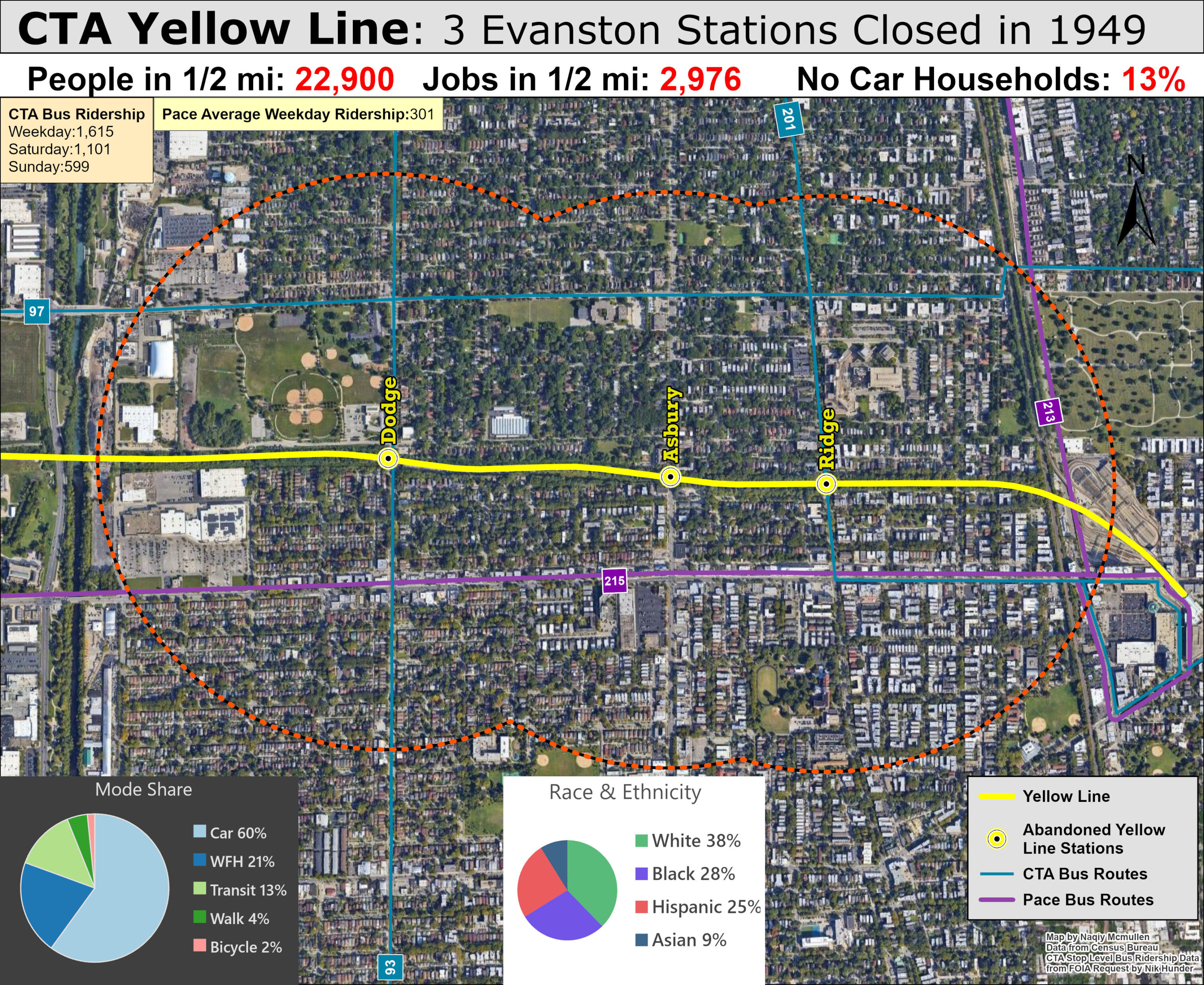
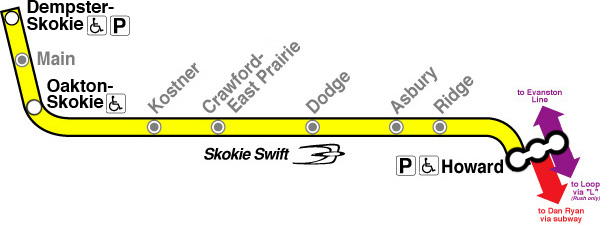
Finally, a look at some stations on the former Niles Branch rapid transit line, which closed in 1949 but was shortly resurrected as the Skokie Swift in 1964, now named the Yellow Line, although many still refer to it by its former moniker. I mapped these former Evanston stations because I live nearby, but also because I think it is a huge shame that an existing rapid transit line runs though dense diverse neighborhoods without benefiting residents, who must rely on slow, infrequent bus service for transit options.
The Niles Center branch ran local rapid transit service on the North Shore Line interurban bypass route, built to avoid congested tracks through the wealthy North Shore towns, saving up to 20 minutes on Milwaukee-Chicago trips. The rapid transit route served largely unpopulated areas beyond Evanston, intending to induce profitable real estate developments and increase property values. Before the suburban growth machine could reach the outlying areas along the route, the Great Depression hit, hampering prospects for speculative suburban development. The minimal patronage along the route served by a one car shuttle, two cars at rush hour, similar to the train consist today.
When CTA took over the private rail operators in 1948, the heavy losses incurred by this line made it the first route under consideration for the chopping block. This ultimately proved to be another short sighted decision by the new transit agency, as the desired growth that had eluded Skokie prior to WW2 finally reached the small village. Returning white soldiers flocked to single family homes bolstered by affordable federal subsidized mortgages and new highways likes the Edens Expressway, The population of Skokie boomed from only 7,000 in 1940 to over 60,000 in 1960.
The private North Shore Skokie Valley interurban line continued to operate following the closure of the rapid transit line, serving several of the stations shown in the map below which lists all the former rapid transit stations. Ultimately private trains could not hope to compete with publicly funded free automobile infrastructure. The North Shore Line route along the lakefront was abandoned in 1955 with the company putting all of its focus on the higher speed Skokie Valley route, which too was ultimately doomed by the catastrophic effects of rapidly rising automobile use, ending service in 1962.
The post WW2 detestation of cities was enabled with glee by mid century planners who viewed cars and suburbia as virtuous cures for the vices of dense urban communities spurred by rapid transit, but even they understood dense city centers like the Loop were still required for economic vitality. It would be geometrically impossible to have every suburban worker drive into downtown Chicago without destroying the office buildings the workers were commuting too for parking and highways, so mid century transit planners began formulating transit aimed at suburban commuters who could drive to train stations with ample parking and take the train to office jobs, while still driving for everything outside commuting. This mindset led CTA to buying the defunct Skokie Valley alignment to test this new model of transit, aided by new federal funding for transit projects. The pilot was a massive success with ridership far exceeding initial projections. It showed that transit could compete with cars for CBD commuters if service was fast and frequent and congestion and limited parking provided enough disincentives to driving.
Rapid transit aimed at drivers working downtown became the national model and influenced Great Society Metros like BART and WMATA which managed to succeed due to historical dense downtowns, although newer societies attempting to duplicate this model have largely failed at generating significant ridership due to limited downtown employment and the ease of driving into these minor downtowns — factors accelerated by shifting pandemic employment trends.
The Skokie Swift initially opened with only two stations but an infill station was opened in downtown Skokie in 2012. Discussions of extensions to Old Orchard shopping mall occurred in the mid 2000s along with potential infill station in Evanston but both studies led nowhere due to community opposition and lack of funding, although the talks of reviving Old Orchard extension recently arose due to more positive perceptions of transit from Skokie leaders.
While an extension to Old Orchard would likely be costly, infill stations in Evanston as well as former stations in Skokie could be completed at reasonable costs if constructed frugally, especially considering the small size of Yellow Line trains allows smaller stations and platforms. There are more people and jobs in walking distance of these former rapid transit stations than near the planned RLE stations, as well as worse bus service due to straddling the Chicago city boundary. While I don’t think rebuilding these stations should be an urgent priority over other more pressing transit needs — improving bus service would be much cheaper and easier— but if CTA is spending billions of dollars to expand access to the L to improve racial equity, there are numerous opportunities to spend the money more effectively and efficiently with infill stations like this without added costly new tracks.
Conclusion
These maps showing greater density and transit supportive land use around former Chicago rapid transit branches and stations is not to disparage the Red Line Extension and leaders and community members who support it, but merely an attempt convey the real obstacles to generating ridership for the project. If greater density and ridership did not stop CTA from abandoning low performing lines in the past, why would a new line serving even lower density and further away neighborhoods be more successful?
I understand the rationale behind fulfilling a promise made decades ago and serving residents and neighborhoods in need, but the costs simply outweigh the benefits with the rapidly rising cost of transit construction in the US. Cost reforms to reduce the cost of the project would make it a more beneficial project, but as it stands, the RLE could severely limit future financial flexibility for large capital projects, especially with rising interest rates on bonds issued to fund the project. With a complete rebuild needed on the Forest Park branch and an expensive new State/Lake elevated station (projected to cost $444 million!) CTA needs to be smart with limited capital dollars.
Tearing down these former branches and stations has been acknowledged as mistake but removing rapid transit from dense areas is a mistake many cities made. Wasting billions on a project with marginal benefits is another mistake that plagues transit agencies and leaders who often view transit projects as jobs programs more than actual transportation. Illinois put immense faith in Chicagoland transit by providing billions in new funding; agencies should repay this trust by being more transparent, efficient, and efficient with public money. If RLE is too far along to be modified or cancelled than hopefully leaders will learn in the future when it fails deliver on promises that transit must serve dense, urban neighborhoods, not sprawling low density suburban areas.