Introduction
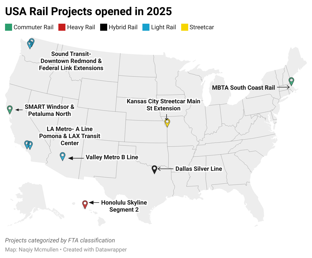
This post summarizes all the new rail opened this year in the USA, providing relevant context and geospatial analysis in individual maps for each new rail project. The national map below shows each new rail line or station classified by specific mode type. This post coincides with opening of Sound Transit’s Federal Way extension, which caps off a busy year in US rail transit expansion.
While analyzing current demographic conditions in walking distance of the new stations is a quick preliminary assessment of the effectiveness and value of the new rail, these maps are not a compressive evaluation. Comparing ridership data released in the upcoming year to initial ridership projections estimated for FTA project ratings is likely the best method for evaluating the success or failure of each project.
Seattle
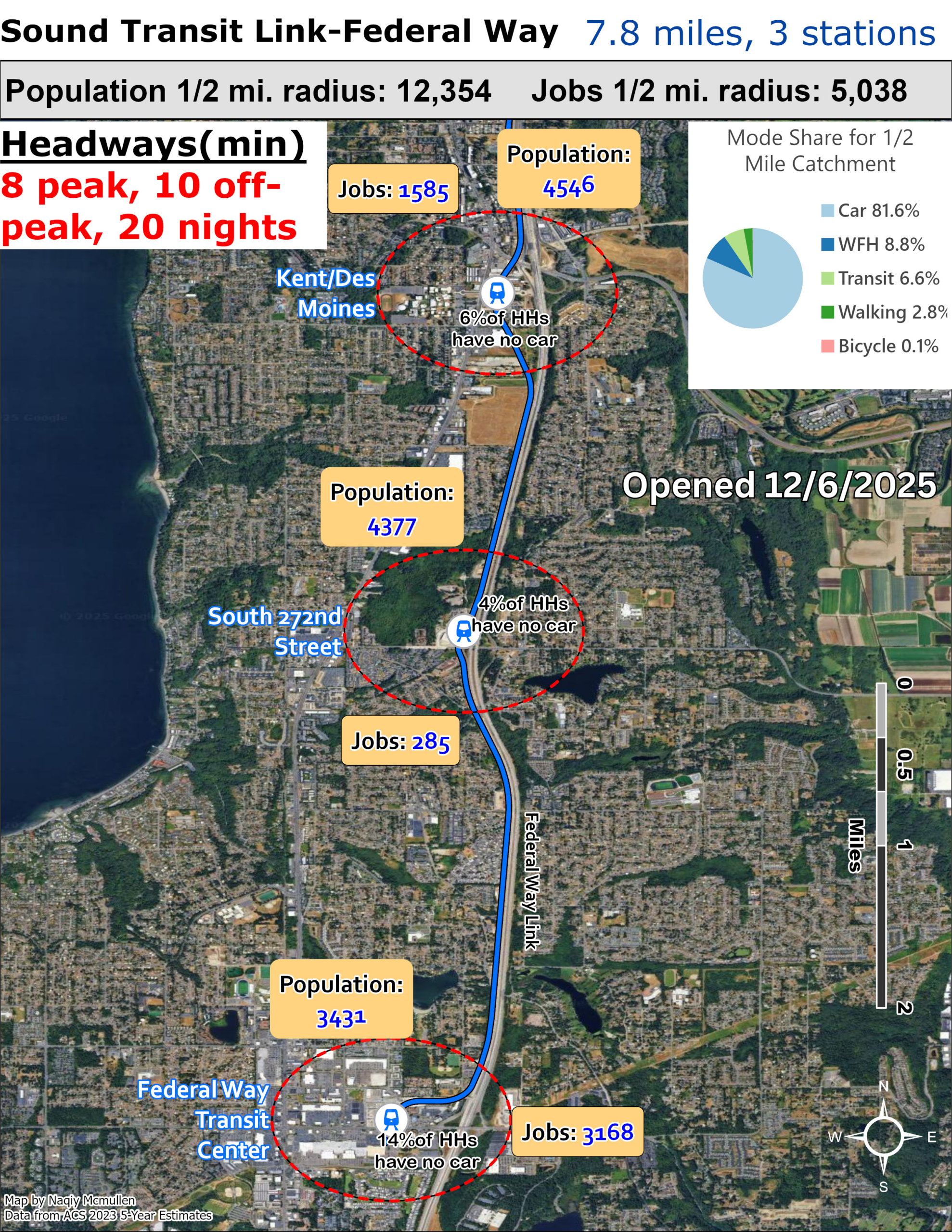
Sound Transit’s Federal Way Link Extension opened to the public on December 6, 2025, marking a transformative moment for South King County’s connectivity to the broader Seattle region. The $2.5 billion project adds 7.8 miles of mostly elevated track Sound Transit extending the 1 Line from Angle Lake Station southward to Federal Way, with three new stations at Kent Des Moines (near Highline College), Star Lake, and Federal Way Downtown. The extension, which was delayed two years due to unstable soil conditions requiring construction of an elevated bridge, ultimately opened ahead of its revised 2026 schedule thanks to streamlined testing processes. Now Federal Way residents can reach Sea-Tac Airport in just 16 minutes and downtown Seattle in approximately 50 minutes, with trains running every eight minutes during peak hours.
The extension’s impact on Seattle and the broader region extends beyond simple convenience. Sound Transit projects the Federal Way Link will carry 18,000 to 23,000 daily passengers by 2028, adding to the 1 Line’s already robust ridership of over 110,000 daily riders. This influx could ease pressure on I-5, Seattle’s chronically congested north-south corridor, while potentially reshaping regional housing markets as South King County becomes more accessible to downtown employment centers. The extension positions communities like Federal Way, Kent, and Des Moines as viable alternatives for commuters priced out of Seattle proper, though initial development around the stations has been sluggish.
Long-term, this infrastructure could catalyze transit-oriented development, bringing affordable housing and commercial activity to areas previously considered peripheral. As King County Metro restructures bus routes to feed into these new stations, the extension promises to weave South King County more tightly into Seattle’s economic and cultural fabric, though realizing this potential will require coordinated land-use planning and sustained political will.
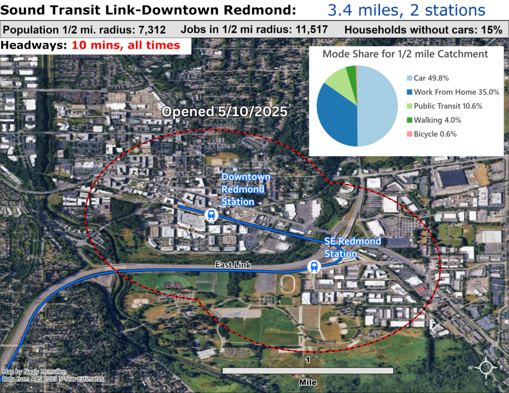
Sound Transit’s Downtown Redmond Link Extension opened to riders on May 10, 2025, marking a historic achievement as the first Sound Transit 3 project to reach completion. The $1.5 billion extension adds 3.4 miles and two stations to the 2 Line at Marymoor Village and Downtown Redmond, completing the Eastside terminus of what will eventually become a cross-region connection. The Marymoor Village station features 1,400 new parking spaces and provides access to Marymoor Park’s concerts and recreation, while the Downtown Redmond station sits adjacent to Redmond Town Center’s shops and restaurants, seamlessly integrating with the Central Connector Trail. Voters approved this extension in 2016, and its completion remained on schedule and within budget despite regional construction challenges. When the final segment across Lake Washington opens in early 2026, connecting at International District/Chinatown Station, riders will enjoy a 30-minute transit time to downtown Seattle and 14-minute trip to Bellevue, with trains running every ten minutes throughout the day.
The extension’s broader implications for Seattle extend beyond mere mobility. By bringing reliable transit to Redmond’s tech corridor—home to Microsoft and countless startups—the connection could reshape regional commuting patterns and ease pressure on State Route 520 and I-90, two of Seattle’s most congested eastbound corridors. More significantly, the extension positions Redmond as a genuine alternative employment center to Seattle proper, potentially redistributing job growth and residential development across King County rather than concentrating it downtown.
Transit-oriented development around these stations could create new high-density neighborhoods on the Eastside, offering housing options for workers who might otherwise compete for Seattle’s limited inventory. Long-term, this infrastructure transforms the Puget Sound region from a Seattle-centric hub into a genuinely polycentric metropolitan area, where suburban communities function as interconnected nodes rather than bedroom communities, fundamentally altering the region’s economic geography.
Los Angeles
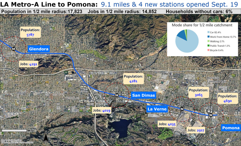
LA Metro’s A Line extension to Pomona opened on September 19, 2025, marking a historic return of passenger rail service to the San Gabriel Valley’s Foothill Cities after a 74-year absence. The $1.5 billion, 9.1-mile extension adds four new stations in Glendora, San Dimas, La Verne, and Pomona, stretching the world’s longest light rail line to an impressive 57.6 miles from Pomona through Pasadena and downtown Los Angeles to Long Beach. Crucially, the Pomona North station provides transfers between Metro and Metrolink’s San Bernardino Line, creating the first rail connection between the San Gabriel Valley’s Foothill Cities and the Inland Empire since the streetcar era. The extension serves over a dozen colleges including Cal Poly Pomona, University of La Verne, and Mt. San Antonio College, while also improving access to the Pomona Fairplex, which will host cricket during the 2028 Olympics. Funded by Los Angeles County’s Measures R and M plus state grants, the project represents Metro’s ninth completed infrastructure enhancement as part of its 28 by 28 Initiative preparing for the Olympic Games.
The extension’s impact reverberates far beyond mere connectivity, potentially reshaping Southern California’s historically fragmented transit landscape. By offering commuters a viable alternative to the perpetually congested I-10 and 210 freeways, the A Line could catalyze a fundamental shift in regional travel patterns while spurring transit-oriented development around stations that have languished underdeveloped for decades. The Metrolink connection transforms the equation entirely, enabling seamless rail travel between the Inland Empire and coastal employment centers—a corridor that has depended almost exclusively on automobiles. For the San Gabriel Valley’s growing college population, the extension democratizes access to higher education by eliminating the need for car ownership. Long-term, this infrastructure could help deconcentrate Los Angeles County’s economic activity, positioning Pomona and neighboring cities as legitimate alternatives to increasingly unaffordable coastal communities while potentially reducing the region’s notorious air pollution and traffic congestion.
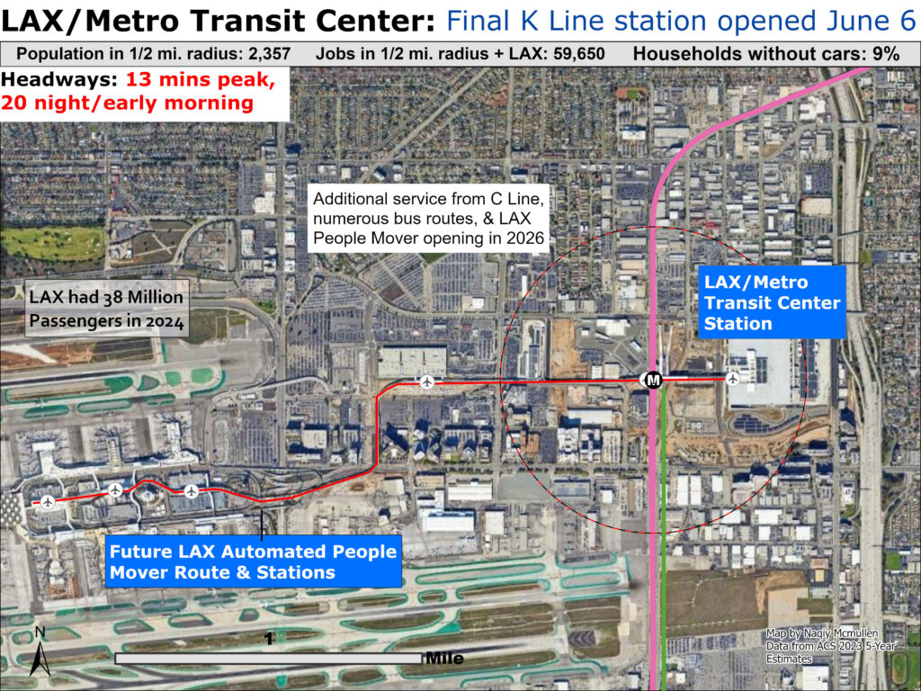
LA Metro’s LAX/Metro Transit Center opened on June 6, 2025, marking a transformative milestone for one of the world’s busiest airports by finally bringing rail service directly to LAX’s doorstep. The multimodal hub at Aviation Boulevard and 96th Street serves both the C Line, which now terminates at the LAX station running from Norwalk, and the K Line, which runs seamlessly from Redondo Beach to the E Line at Expo/Crenshaw. Designed by Grimshaw Architects, the station features 16 bus transfer bays, secured bicycle parking, restrooms, a customer service center, and Glenn Kaino’s suspended sculpture “The Distance of the Sun.” Until the highly anticipated LAX Automated People Mover opens in mid-2026, travelers rely on free shuttle buses running every 10 minutes to reach airport terminals. When the 2.25-mile elevated People Mover begins service, expected around June 2026, it will connect six stations including three in the central terminal area, economy parking, the consolidated rental car facility, and the LAX/Metro Transit Center, with trains arriving every two minutes during peak hours and completing the end-to-end journey in just 10 minutes at speeds up to 47 miles per hour.
The economic and transportation implications ripple far beyond LAX’s notorious horseshoe. The People Mover is projected to transport 30 million passengers annually and eliminate an estimated 42 million vehicle miles, potentially transforming Southern California’s chronically congested airport access while reducing emissions. For Los Angeles Metro, the connection represents the culmination of decades-long efforts to integrate the region’s eighth-busiest airport into its expanding rail network.
The station positions neighborhoods like Inglewood, Redondo Beach, and South Los Angeles within a single-transfer journey to international terminals, democratizing air travel access for communities historically dependent on expensive rideshares or inconvenient bus connections. Economically, seamless transit access could catalyze development around C and K Line stations while making LAX a more competitive employment hub for workers priced out of car ownership. As Los Angeles prepares to host the 2026 World Cup and 2028 Olympics, this infrastructure promises to reshape the region’s transportation paradigm, demonstrating that even in car-centric Southern California, world-class transit connectivity is achievable—though the People Mover’s repeated delays remind us that ambition and execution remain distinct challenges.
Phoenix
Phoenix Valley Metro’s South Central Extension/Downtown Hub opened on June 7, 2025, transforming the region’s transit landscape by introducing the first two-line light rail system in metro Phoenix. The $1.34 billion, 5.5-mile extension runs south along Central Avenue from downtown to Baseline Road, adding eight new stations and creating the north-south B Line (Metro Parkway to Baseline/Central Avenue) and east-west A Line (Downtown Phoenix Hub to Gilbert Road/Main Street). Originally scheduled to open in 2034, the project was accelerated by a decade thanks to Phoenix’s Transportation 2050 voter-approved sales tax initiative. The extension is projected to add 8,000 riders per day to the now 35-mile system, connecting historically underserved South Phoenix neighborhoods to employment centers, healthcare facilities, and educational institutions across the Valley. The project created over 5,000 local jobs, with more than 600 workers hired directly from south Phoenix communities, while installing enhanced bike lanes, pedestrian pathways, and over 550 new trees along the corridor.
The extension carries profound implications for regional equity, economics, and environmental sustainability. By bringing reliable transit to predominantly Latino and lower-income South Phoenix neighborhoods—areas largely bypassed by the original 2008 system—the extension addresses longstanding transportation inequities while potentially catalyzing economic development along Central Avenue. Valley Metro has attracted more than $17.5 billion in public and private investment development since 2008, suggesting similar growth could materialize in South Phoenix, though gentrification concerns loom large.
Environmentally, the expansion offers car-dependent Phoenix residents alternatives to driving in a region notorious for sprawl and poor air quality. However, the project’s initial community backlash—centered on reducing Central Avenue from four lanes to two in each direction—revealed tensions between mobility priorities, with opponents gathering enough signatures to force a referendum on future expansions. Long-term, as Valley Metro works toward a 50-mile system by 2030, the South Central Extension represents a crucial test: can transit-oriented development uplift underserved communities without displacing them, and can Phoenix reshape its automobile-centric identity into something more sustainable and equitable?
Honolulu
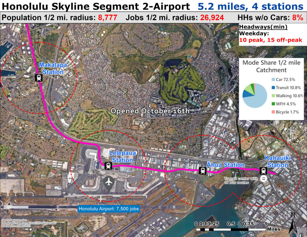
Honolulu’s Skyline Segment 2 opened on October 16, 2025, expanding Hawaii’s historic rail system by five additional miles and four new stations, extending passenger service from East Kapolei to Middle Street with extended operating hours from 4:00 a.m. to 10:30 p.m. daily. The segment connects critical employment hubs including Joint Base Pearl Harbor-Hickam, Daniel K. Inouye International Airport, and the Māpunapuna industrial area. Technically, Skyline represents a groundbreaking achievement as the first fully autonomous, urban light railway system in the United States, operating at Grade of Automation 4 with fully driverless trains. The system utilizes 750 V DC third-rail electrification with automated train control enabling maximum speeds of 55 mph, averaging about 30 mph along the elevated guideway. The fleet consists of 20 four-car Hitachi Rail trainsets, each with capacity for 800 passengers, featuring air conditioning, Wi-Fi, bicycle and surfboard storage, and platform screen doors for enhanced safety. Trains arrive every 10 minutes throughout the day, with the system projected to grow from approximately 3,900 daily riders currently to 25,000 with Segment 2, and ultimately 85,000 daily riders when Segment 3 opens to downtown Honolulu in 2031.
The extension’s broader implications touch transportation equity, economic development, and environmental sustainability across Oahu. By connecting West Oahu’s working-class communities to major employment centers, Skyline democratizes access to jobs previously requiring car ownership—particularly significant given that riders can now travel from East Kapolei to the airport in just 32 minutes with guaranteed punctuality. When fully complete, the system is expected to eliminate an estimated 40,000 car trips per day from the city’s streets, addressing Oahu’s notorious traffic congestion along its narrow 45-mile-long urban corridor. Environmentally, the electrically powered system aligns with Hawaii’s commitment to 100% renewable energy by 2045, potentially catalyzing transit-oriented development around stations and protecting the island’s delicate ecosystem.
Kansas City
Kansas City’s KC Streetcar Main Street Extension opened on October 24, 2025, marking a transformative expansion that more than doubled the system from its original 2.2-mile downtown route. The $352 million, 3.5-mile extension adds 16 new stops connecting Union Station to 51st Street and Brookside Boulevard near the University of Missouri-Kansas City, creating a 5.7-mile corridor from the River Market through downtown, Midtown, Westport, the Country Club Plaza, and UMKC. Unlike fully automated systems like Honolulu’s Skyline, the KC Streetcar operates with human drivers aboard bi-directional CAF Urbos 3 vehicles approximately 77 feet long, equipped with advanced driver assist systems, three braking systems including friction, dynamic, and emergency track brakes, and capable of reaching maximum speeds of 43 mph. The streetcar fleet expanded from six to 14 vehicles with the addition of eight new cars featuring enhanced video surveillance, improved passenger information displays, and upgraded communication systems. The extension features electric fixed-rail service that is free to ride, funded entirely by a transportation development district through special assessments and a one percent sales tax collected only within neighborhoods along the route, making Kansas City one of the few American cities offering fare-free transit. Service operates with trains arriving frequently throughout the day, connecting major employment centers, cultural institutions including the Nelson-Atkins Museum and National WWI Museum, and Kansas City’s densest residential neighborhoods.
The extension’s economic and transportation implications extend well beyond simple mobility improvements, touching fundamental questions of equity, development patterns, and regional identity. By connecting historically underserved neighborhoods along Main Street to downtown employment and the Plaza’s commercial district, the streetcar democratizes access for residents who cannot afford car ownership while potentially catalyzing transit-oriented development. Environmentally, the fare-free, zero-emission transit service offers car-dependent Kansas City a viable alternative for local trips while alleviating parking pressures in dense urban areas.
Dallas
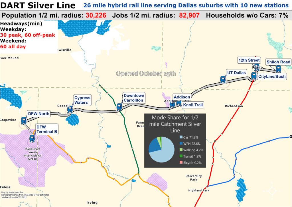
The Dallas Area Rapid Transit (DART) Silver Line, a 26-mile Diesel Multiple Unit (DMU) regional rail corridor, commenced service on October 25, 2025 after years of planning and construction. Operating between Shiloh Road in Plano and DFW International Airport’s Terminal B, the Silver Line traverses seven cities—Plano, Richardson, Dallas, Addison, Carrollton, Coppell, and Grapevine—across Collin, Dallas, and Tarrant counties, with 10 new stations integrated into the broader transit network. (DART)
Unlike DART’s electrically powered light rail, the Silver Line uses state-of-the-art Stadler DMU trains that meet EPA Tier 4 emissions standards and comply with Federal Railroad Administration (FRA) requirements for shared freight corridors. These self-propelled units offer comfortable seating, level boarding, USB charging, and bicycle storage, and are supported by positive train control systems for enhanced safety. (DART)
Operational frequency is every 30 minutes at peak and 60 minutes off-peak/weekends, with daily service extending from early morning to late night to accommodate commuters and airport travelers. (DART)
The project’s implications extend beyond mobility. By creating a direct east-west rail link that interfaces with existing DART light rail, bus networks, and TEXRail at DFW, the Silver Line significantly reduces reliance on highway travel, improves access to employment and educational centers, and catalyzes transit-oriented development along the corridor. Early indications suggest enhanced regional connectivity and potential for economic growth and land-use transformation in adjacent communities. (DART)
Marin County
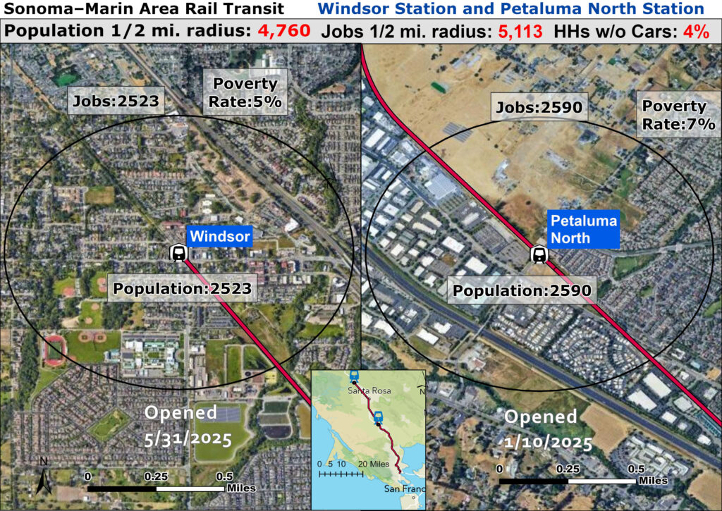
The Sonoma-Marin Area Rail Transit (SMART) system expanded commuter rail service in 2025 with the opening of two new stations: Petaluma North on January 10 and Windsor on May 31. Petaluma North is an infill station on the existing corridor, while the Windsor station extends SMART service roughly 3 miles north from the Sonoma County Airport terminus, adding approximately 48 miles of operational rail and increasing the network to 14 total stations. Both stations support diesel multiple unit (DMU) operations with Positive Train Control safety systems and integrated non-motorized pathways for bicycles and pedestrians, reflecting investments in sustainable regional mobility.
Combined capital spending for these projects derives from state and regional grants, local sales tax measures, and federal funds; Petaluma North’s build-out was estimated at around $11 million and Windsor’s extension was part of a larger multi-mile reconstruction on rehabilitated Northwestern Pacific Railroad right-of-way.
These openings mark SMART’s first system expansion since 2019 and represent tangible progress in a long-term plan to extend rail service northward to Healdsburg and eventually Cloverdale. The new stations improve transit access for commuters, students, and visitors, reduce reliance on Highway 101, and encourage economic activity and transit-oriented development in Marin and Sonoma counties by linking communities more directly to employment centers, ferry connections, and regional destinations.
Boston
The Massachusetts Bay Transportation Authority’s South Coast Rail project represents one of the most consequential expansions of the MBTA Commuter Rail network in decades. On March 24, 2025, Phase 1 of the project commenced revenue service, restoring passenger rail connections between Boston’s South Station and southeastern Massachusetts—specifically Taunton, Freetown, New Bedford, Middleborough, and Fall River—for the first time in 65 years. This service operates as an extension of the existing Middleborough/Lakeville Line, now designated the Fall River/New Bedford Line.
Phase 1 includes six new commuter rail stations, two layover facilities, and substantial reconstruction of the Middleborough Secondary, New Bedford Main Line and Fall River Secondary corridors. Stations such as East Taunton, Freetown, Church Street (New Bedford), and Fall River Depot were built with ADA-compliant high-level platforms, accessible parking, and modern passenger amenities.
The project’s capital cost for Phase 1 was fully funded at approximately $1 billion, covering 37+ miles of upgraded track, bridges, grade crossings, signaling systems, and stations, with construction beginning in earnest in 2019 and substantial completion by late 2024.
Operationally, trains run roughly every 70 minutes on weekdays and every two hours on weekends, with early launch promotions offering fare-free service and free parking to attract riders. Economically and in transportation terms, South Coast Rail reknits a long-disconnected region into the Greater Boston labor market, reducing highway congestion and expanding access to jobs, education, and services. It is expected to stimulate transit-oriented development, boost property values near stations, and catalyze sustainable regional growth. Long-term planning also anticipates further phases that could enhance service frequency and direct routing closer to downtown Taunton and beyond. (Massachusetts Government)
Chicago
Finally, a bonus map for my home city, showing the rebuilt, fully accessible stations on CTA’s Red Line as part of the Red-Purple Modernization project. While the station locations are not new and therefore do not expand access to transit ultimately beyond the new elevators improving accessibility for all, it is still interesting to examine the land use surrounding the stations.
These stations have by far the best land use and highest population density of all the new rail projects opened this year. While the close stop spacing on the North Side Main Line and temporary Argyle station means ultimately were not missed too badly during their prolonged closure, the abundance of car-free households and nearby walkable neighborhoods far exceeding the vast majority of the country is an example of why Chicago needs and deserves better transit in the core; there are many dense neighborhoods that should be in line for new rail transit instead of just rebuilt stations. Sadly CTA is committed to extending the Red Line further south into sprawling low density neighborhoods on the far South Side due to prior promises going back decades and lack of expert leadership. With new funding passed by the state that starved off the impending fiscal cliff and provides local transit agencies with greater financial flexibility in the future, CTA and other agencies should commit to improving transit in the urban core beyond simply throwing improved service hours at the problem without improving the underlying inefficient operations of the system.
If the high cost of rail construction in dense urban areas precludes further rail lines, the city and regional transit authority should commit to an aggressive infrastructure plan to improve high ridership yet slow and frequently bunched bus routes that are the backbone of the local transit system and have the majority of ridership overall.